1990s Maps of Volcano, Hawaii
Explore 4 historic maps of Volcano from the 1990s. These maps offer a rare glimpse into what life looked like during the 1990s — showing old roads, neighborhoods, homes, and landmarks that have changed or disappeared over time.
Whether you're researching your family's past, planning a metal detecting trip, or studying how Volcano's landscape evolved across the 1990s, these high-resolution maps are a powerful tool for exploring the history of this region.
- Focus on a specific era: All maps on this page are from the 1990s, giving you a focused view of this time period.
- See what’s changed: Compare century-old streets, trails, and buildings to today's modern landscape using overlays and satellite layers.
- Research with precision: Use these maps for genealogy, historical research, land use analysis, or educational projects.
- View, download, or print: Maps are fully viewable online in high resolution, and can be downloaded or printed for your own records.
Start exploring Volcano's history through authentic maps from the 1990s. This is your window into the past.
Volcano, HI maps
(4)- 1993 Map of Kulani, 2001 Print
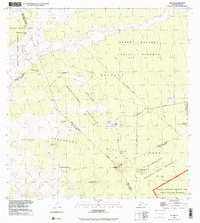 1993 Kulani2001 Print · USGSThe slopes of Mauna Loa appear in the early 1990s as a landscape of massive lava flows and high-altitude reserves. You can trace the footprint of the Kūlani Correctional Facility, the Mauna Loa Boys School, and historical sites like Waiākea Camp (Site).
 - 1994 Map of Puumakaala, 2002 Print
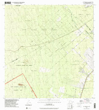 1994 Puumakaala2002 Print · USGSThe Big Island's forested uplands are captured in the 1990s as homesteading and wilderness conservation intersect. Genealogists and historians can trace the layout of the 'Ōla'a Reservation Homesteads and follow an old Railroad Grade through the dense forest.
 - 1995 Map of Kilauea Crater, 2003 Print
 1995 Kilauea Crater2003 Print · USGSThe volcanic heart of the Big Island is frozen in time during the mid-nineties, showing the active vents and craters of the summit. Trace the extent of historical events like the Lava Flow of 1921 and find the Volcano Observatory overlooking Halema'uma'u.
 - 1997 Map of Volcano, 1999 Print
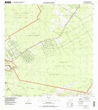 1997 Volcano1999 Print · USGSThe village of Volcano and the active geological landscape of the Big Island are documented here in the late nineties. Researchers can trace historical eruptions like the Lava Flow of 1840 or locate residents in the Olaa Summer Lots.
End of results
Showing maps 1-4 of 4
Top cities near Volcano
Top neighborhoods of Volcano
Frequently asked questions
- What are the different types of historical maps available for Volcano?
- What is the oldest map of Volcano?
- Where can I purchase historical maps of Volcano for my home or office?
- Where can I download high-res historical maps of Volcano?
- Are there historical topographic maps available for Volcano?
- Is there historical aerial imagery available for Volcano?
- Where are historical maps of Volcano sourced from?