1970s Maps of Volcano, Hawaii
Explore 3 historic maps of Volcano from the 1970s. These maps offer a rare glimpse into what life looked like during the 1970s — showing old roads, neighborhoods, homes, and landmarks that have changed or disappeared over time.
Whether you're researching your family's past, planning a metal detecting trip, or studying how Volcano's landscape evolved across the 1970s, these high-resolution maps are a powerful tool for exploring the history of this region.
- Focus on a specific era: All maps on this page are from the 1970s, giving you a focused view of this time period.
- See what’s changed: Compare century-old streets, trails, and buildings to today's modern landscape using overlays and satellite layers.
- Research with precision: Use these maps for genealogy, historical research, land use analysis, or educational projects.
- View, download, or print: Maps are fully viewable online in high resolution, and can be downloaded or printed for your own records.
Start exploring Volcano's history through authentic maps from the 1970s. This is your window into the past.
Volcano, HI maps
(3)- 1975 Map of Hawaii, 1977 Print
 1975 Hawaii1977 Print · USGSThe Big Island in the mid-seventies is captured here as a landscape of volcanic giants and coastal sugar communities. Genealogists and historians can locate former plantation sites like Pepeekeo Mill or trace the routes of the Mamalahoa Highway through Kamuela.
 - 1977 Map of Kilauea Crater, 1981 Print
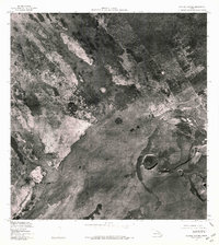 1977 Kilauea Crater1981 Print · USGSHawaii’s volcanic heart is captured in detail during the late 1970s, showing the island's landscape through precise aerial orthophotography. Researchers can study the distinct lava flow patterns and geological structures of Kilauea Crater and Keanakakoi Crater.
 - 1977 Map of Volcano, 1981 Print
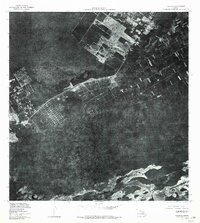 1977 Volcano1981 Print · USGSThe Big Island's volcanic landscape is captured here in the late seventies, showing the proximity of human settlements to active rift zones. Researchers can trace the residential layouts of Volcano and Glenwood alongside Kilauea Iki Crater and Napau Crater.
End of results
Showing maps 1-3 of 3
Top cities near Volcano
Top neighborhoods of Volcano
Frequently asked questions
- What are the different types of historical maps available for Volcano?
- What is the oldest map of Volcano?
- Where can I purchase historical maps of Volcano for my home or office?
- Where can I download high-res historical maps of Volcano?
- Are there historical topographic maps available for Volcano?
- Is there historical aerial imagery available for Volcano?
- Where are historical maps of Volcano sourced from?