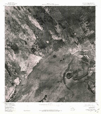
1977 Map of Kilauea Crater
USGS Topo · Published 1981About this map
Kilauea Crater dominates the southeastern quadrant of this orthophotomap, which was produced from aerial photography captured by the U.S. Geological Survey in late 1976 and early 1977. The imagery provides a clear view of the volcanic landscape on the island of Hawaii during a period of significant activity. Beyond the massive central caldera, smaller features such as Keanakakoi Crater and Pauahi Crater are visible to the south and east. The contrast between the dark lava flows and the surrounding vegetation reveals the paths of past eruptions, showing how the landscape is constantly reshaped by volcanic forces. This orthophoto quadrangle serves as a precise record of the terrain as it existed just before the turn of the decade.
Find a feature on this map
3 named features on this map. Tap any name to fly to it.
Don’t see what you’re looking for? This feature index may not catch every label — zoom into the map to look around manually.
Map Details
Editions of this 1977 Kilauea Crater Map
This is the sole edition of this map. No revisions or reprints were ever made.
Other maps of this area

1917 · Hilo
USGS Topo · 1:62,500

1921 · Kilauea
USGS Topo · 1:62,500

1922 · Puna
USGS Topo · 1:62,500

1924 · Kilauea
USGS Topo · 1:62,500

1924 · Puna
USGS Topo · 1:62,500

1930 · Humuula
USGS Topo · 1:62,500

1932 · Hilo
USGS Topo · 1:62,500

1954 · Hawaii South
USGS Topo · 1:250,000

1954 · Hawaii North
USGS Topo · 1:250,000
1956 · Puu Ulaula
USGS Topo · 1:24,000