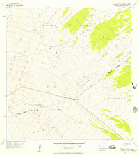
1956 Map of Puu Ulaula
USGS Topo · Published 1957About this map
Mauna Loa dominates this mid-century survey, its slopes defined by a chronological series of volcanic events including the Lava Flow of 1852, the Lava Flow of 1881, and more recent activity from the 1930s and 1940s. The landscape is a study in early scientific and recreational infrastructure within the Hawaii National Park and the Mauna Loa Forest and Game Reserve. Human presence is marked by high-altitude utility, specifically at the TV Relay Station and Weather Station, while travelers could find shelter at the Rest House near the peak of Puu Ulaula. The map meticulously tracks the intersection of the North Hilo and Kau District boundary as it crosses over cinder cones like Puu Kuluu. A network of simple trails and a jeep trail provide the only passage through this volatile terrain during the 1950s.
Find a feature on this map
22 named features on this map. Tap any name to fly to it.
Don’t see what you’re looking for? This feature index may not catch every label — zoom into the map to look around manually.
Map Details
Editions of this 1956 Puu Ulaula Map
2 editions found
Other maps of this area

1921 · Kilauea
USGS Topo · 1:62,500

1924 · Kilauea
USGS Topo · 1:62,500

1927 · Kaohe
USGS Topo · 1:62,500

1928 · Mauna Loa
USGS Topo · 1:62,500

1930 · Humuula
USGS Topo · 1:62,500

1930 · Kaohe
USGS Topo · 1:62,500

1954 · Hawaii South
USGS Topo · 1:250,000

1954 · Hawaii North
USGS Topo · 1:250,000

1956 · Puu Oo
USGS Topo · 1:24,000

1956 · Puu Koli
USGS Topo · 1:24,000