1900s (20th Century) Maps of Waieli, Kauai County
Explore 5 historic maps of Waieli from the 1900s (20th Century). These maps offer a rare glimpse into what life looked like during the 1900s — showing old roads, neighborhoods, homes, and landmarks that have changed or disappeared over time.
Whether you're researching your family's past, planning a metal detecting trip, or studying how Waieli's landscape evolved across the 1900s, these high-resolution maps are a powerful tool for exploring the history of this region.
- Focus on a specific era: All maps on this page are from the 1900s, giving you a focused view of this time period.
- See what’s changed: Compare century-old streets, trails, and buildings to today's modern landscape using overlays and satellite layers.
- Research with precision: Use these maps for genealogy, historical research, land use analysis, or educational projects.
- View, download, or print: Maps are fully viewable online in high resolution, and can be downloaded or printed for your own records.
Start exploring Waieli's history through authentic maps from the 1900s. This is your window into the past.
Waieli, Kauai County maps
(5)- 1954 Map of Kauai
 1954 Kauai1954 Print · USGSKauai and Niihau are shown during a period of transition in the early fifties as plantation-era infrastructure began to change. Researchers can trace the Kilauea Sugar Plantation Railroad, the Anahola Settlement, and remote sites on Niihau like Puuwai.
 - 1963 Map of Kekaha, 1965 Print
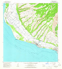 1963 Kekaha1965 Print · USGSThe southwestern Kauai coastline in the early sixties was a unique blend of sugar plantation infrastructure and strategic military outposts. Genealogists and historians can trace local life through Kekaha and Mana, alongside technical landmarks like the Kekaha Ditch and Kaunalewa Shaft.2 unique versions available
 - 1967 Map of Kauai
 1967 Kauai1967 Print · USGSThe Garden Isle and Niihau are shown here in the mid-sixties, capturing the island's transition from plantation roots to a more modern infrastructure. Genealogists can trace family connections in Moloaa Settlement or find coastal landmarks like Nonopapa and Kilauea Point Light.
 - 1970 Map of Kauai, 1974 Print
 1970 Kauai1974 Print · USGSThe islands of Kauai and Niihau are shown during the early 1970s, capturing the balance between military expansion and preserved wilderness. Researchers can trace the layout of Niihau's elusive villages like Puwai or explore Kauai's industrial landscape at Koloa Mill and Port Allen.2 unique versions available
 - 1983 Map of Kekaha, 1984 Print
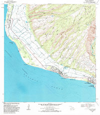 1983 Kekaha1984 Print · USGSThe western coast of Kauai was a landscape of military activity and irrigation engineering in the early eighties. Genealogists and researchers can trace the neighborhoods of Kekaha and Waimea, locating landmarks like St Theresa Sch and Kikiaola Harbor.
End of results
Showing maps 1-5 of 5
Frequently asked questions
- What are the different types of historical maps available for Waieli?
- What is the oldest map of Waieli?
- Where can I purchase historical maps of Waieli for my home or office?
- Where can I download high-res historical maps of Waieli?
- Are there historical topographic maps available for Waieli?
- Is there historical aerial imagery available for Waieli?
- Where are historical maps of Waieli sourced from?