Old Maps of Haiku, Hawaii for Academic Research
Study the evolution of Haiku with 9 high-resolution historic maps. Whether you're teaching, researching, or modeling changes in land use, these maps provide essential visual documentation of urban, environmental, and geographic change.
- Analyze long-term change: Track patterns in development, transportation, and natural features.
- Ideal for environmental or urban studies: Support academic projects with primary historical map data.
- Use in the classroom or lab: Educators and researchers rely on these maps to bring historical context to life.
These maps are a powerful tool for teaching, research, and visualizing how Haiku has changed over the decades.
Haiku, HI maps
(9)- 1954 Map of Maui
 1954 Maui1954 Print · USGSThe central Hawaiian Islands are shown during the mid-fifties, detailing the agricultural and coastal infrastructure of Maui, Lanai, and Molokai. Genealogists and researchers can trace plantation-era history at Haliimaile Camp, locate old harbors like Kaumalapau Harbor, or explore the early bounds of Haleakala National Park.
 - 1957 Map of Haiku, 1959 Print
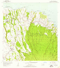 1957 Haiku1959 Print · USGSCoastal Maui in the late fifties shows a landscape shaped by sugar plantation infrastructure and small rural communities. Genealogists and historians can trace worker settlements like Filipino Camp, locate the Haiku School, and follow the old Hana Highway corridor.3 unique versions available
 - 1966 Map of Maui
 1966 Maui1966 Print · USGSThe central islands of Maui, Molokai, Lanai, and Kahoolawe are shown in detail during the mid-1960s as plantation life and early tourism coexisted. Genealogists and researchers can trace family locations in old plantation towns like Puunene, the harbor at Lahaina, and Hoolehua on Molokai.
 - 1974 Map of Maui
 1974 Maui1974 Print · USGSMid-century Hawaii is captured here through the detailed landscapes of Maui, Molokai, Lanai, and Kahoolawe as they appeared in the 1970s. Researchers can trace the layout of island hubs like Lahaina and Lanai City alongside remote landmarks like Wainapanapa Cave.2 unique versions available
 - 1983 Map of Haiku, 1984 Print
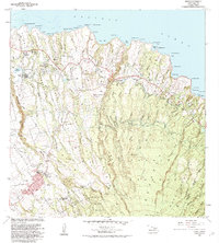 1983 Haiku1984 Print · USGSMaui's windward coast and upcountry slopes are captured here in the early eighties, showing the transition from agricultural traditions to modern residential growth. Researchers can locate family sites and landmarks like St Joseph Sch, the Maui Veterans Cemetery, and the Rodeo Arena near Makawao.2 unique versions available
 - 1992 Map of Haiku, 1999 Print
 1992 Haiku1999 Print · USGSThe North Shore of Maui in the 1990s reveals a landscape of deep gulches and historical homesteads before the turn of the millennium. Genealogists and researchers can trace family lands in Haleakala Homesteads or locate the Mau Veterans Cemetery and Pauwela Point Lighthouse Pk.
 - 2013 Map of Haiku, 2013 Print
 2013 Haiku2013 Print · USGSCovers Haiku, including Kaupakalua, Pauwela, and other nearby areas
 - 2017 Map of Haiku, 2017 Print
 2017 Haiku2017 Print · USGSCovers Haiku, including Kaupakalua, Pauwela, and other nearby areas
 - 2024 Map of Haiku, 2024 Print
 2024 Haiku2024 Print · USGSMaui's northern coastline and Upcountry region are shown here in modern detail, highlighting the area's agricultural and maritime heritage. Researchers can trace historic family locations near Pauwela Hongwanji Cem, the Lowrie Ditch water system, and coastal settlements like Huelo and Kailua.
End of results
Showing maps 1-9 of 9
Top cities near Haiku
Frequently asked questions
- What are the different types of historical maps available for Haiku?
- What is the oldest map of Haiku?
- Where can I purchase historical maps of Haiku for my home or office?
- Where can I download high-res historical maps of Haiku?
- Are there historical topographic maps available for Haiku?
- Is there historical aerial imagery available for Haiku?
- Where are historical maps of Haiku sourced from?