Old Maps of Hā‘ō‘ū, Hawaii for Metal Detecting
Plan your next treasure hunt with 9 historic maps of Hā‘ō‘ū. Find old homesites, ghost towns, trails, and gathering spots that may be lost to time — perfect for identifying promising metal detecting locations.
- Locate forgotten sites: Uncover places like long-lost settlements, abandoned rail lines, or gathering spots.
- Plan better hunts: Use map overlays combined with LiDAR or satellite views to narrow in on historically rich areas.
- Made for detectorists: Thousands of hobbyists use these maps to discover relics, coins, and hidden history.
Use these historic maps to boost your research and find new opportunities beneath the surface of Hā‘ō‘ū.
Hā‘ō‘ū, HI maps
(9)- 1954 Map of Maui
 1954 Maui1954 Print · USGSThe central Hawaiian Islands are shown during the mid-fifties, detailing the agricultural and coastal infrastructure of Maui, Lanai, and Molokai. Genealogists and researchers can trace plantation-era history at Haliimaile Camp, locate old harbors like Kaumalapau Harbor, or explore the early bounds of Haleakala National Park.
 - 1957 Map of Kipahulu, 1959 Print
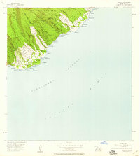 1957 Kipahulu1959 Print · USGSMaui's southeastern coast comes to life in this mid-century survey, from the high ridges to the shore. Researchers can trace historic sites like Kapekuua Heiau, the Old Landing at Maulili Bay, and family-named points such as Kakanoni Pt.2 unique versions available
 - 1966 Map of Maui
 1966 Maui1966 Print · USGSThe central islands of Maui, Molokai, Lanai, and Kahoolawe are shown in detail during the mid-1960s as plantation life and early tourism coexisted. Genealogists and researchers can trace family locations in old plantation towns like Puunene, the harbor at Lahaina, and Hoolehua on Molokai.
 - 1974 Map of Maui
 1974 Maui1974 Print · USGSMid-century Hawaii is captured here through the detailed landscapes of Maui, Molokai, Lanai, and Kahoolawe as they appeared in the 1970s. Researchers can trace the layout of island hubs like Lahaina and Lanai City alongside remote landmarks like Wainapanapa Cave.2 unique versions available
 - 1983 Map of Kipahulu
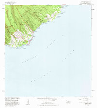 1983 Kipahulu1983 Print · USGSSoutheast Maui’s coast is captured in the early eighties as the Piilani Highway winds through ancient valley landscapes. Researchers can trace historic shorelines and cultural sites including a Historical Monument, Wailua Falls, and several native Heiau.2 unique versions available
 - 1995 Map of Kipahulu, 2002 Print
 1995 Kipahulu2002 Print · USGSThe Hāna District of Maui remains remarkably preserved in the mid-nineties, showing the isolated communities of the southeast coast. Researchers can trace land grants and local history through the Waiohonu-Kaki'o Homesteads, a local cemetery, and the Seven Pools near Kipahulu.
 - 2013 Map of Kipahulu, 2013 Print
 2013 Kipahulu2013 Print · USGSCovers Hā‘ō‘ū, including Koali, Kīpahulu, and other nearby areas
 - 2017 Map of Kipahulu, 2017 Print
 2017 Kipahulu2017 Print · USGSCovers Hā‘ō‘ū, including Koali, Kīpahulu, and other nearby areas
 - 2024 Map of Kipahulu, 2024 Print
 2024 Kipahulu2024 Print · USGSThe windward Maui coast around Kipahulu is detailed here as it appears today, from the high wilderness to the sea. Researchers can locate significant sites like the Palapala Ho'omau Church Cem and landmarks such as the Pools of 'Ohe'o.
End of results
Showing maps 1-9 of 9
Frequently asked questions
- What are the different types of historical maps available for Hā‘ō‘ū?
- What is the oldest map of Hā‘ō‘ū?
- Where can I purchase historical maps of Hā‘ō‘ū for my home or office?
- Where can I download high-res historical maps of Hā‘ō‘ū?
- Are there historical topographic maps available for Hā‘ō‘ū?
- Is there historical aerial imagery available for Hā‘ō‘ū?
- Where are historical maps of Hā‘ō‘ū sourced from?