1900s (20th Century) Maps of Kahului, Hawaii
Explore 11 historic maps of Kahului from the 1900s (20th Century). These maps offer a rare glimpse into what life looked like during the 1900s — showing old roads, neighborhoods, homes, and landmarks that have changed or disappeared over time.
Whether you're researching your family's past, planning a metal detecting trip, or studying how Kahului's landscape evolved across the 1900s, these high-resolution maps are a powerful tool for exploring the history of this region.
- Focus on a specific era: All maps on this page are from the 1900s, giving you a focused view of this time period.
- See what’s changed: Compare century-old streets, trails, and buildings to today's modern landscape using overlays and satellite layers.
- Research with precision: Use these maps for genealogy, historical research, land use analysis, or educational projects.
- View, download, or print: Maps are fully viewable online in high resolution, and can be downloaded or printed for your own records.
Start exploring Kahului's history through authentic maps from the 1900s. This is your window into the past.
Kahului, HI maps
(11)- 1954 Map of Maui
 1954 Maui1954 Print · USGSThe central Hawaiian Islands are shown during the mid-fifties, detailing the agricultural and coastal infrastructure of Maui, Lanai, and Molokai. Genealogists and researchers can trace plantation-era history at Haliimaile Camp, locate old harbors like Kaumalapau Harbor, or explore the early bounds of Haleakala National Park.
 - 1954 Map of Paia, 1956 Print
 1954 Paia1956 Print · USGSIn the mid-fifties, the sugar plantation landscape of central Maui was a dense network of worker communities and industrial rail. Genealogists and historians can trace specific residential enclaves like Japanese Village 1, Russian Village, and Alabama Village near the Puunene mills.2 unique versions available
 - 1955 Map of Wailuku, 1957 Print
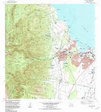
 1955 Wailuku1957 Print · USGSMaui in the mid-fifties shows a bustling plantation and civic hub as Wailuku expands and the sugar industry thrives. Genealogists and researchers can trace local landmarks like Baldwin High School, the Kahului Railroad, and worker housing at Ah Fong Village or McGerrow Village.2 unique versions available
 - 1966 Map of Maui
 1966 Maui1966 Print · USGSThe central islands of Maui, Molokai, Lanai, and Kahoolawe are shown in detail during the mid-1960s as plantation life and early tourism coexisted. Genealogists and researchers can trace family locations in old plantation towns like Puunene, the harbor at Lahaina, and Hoolehua on Molokai.
 - 1974 Map of Maui
 1974 Maui1974 Print · USGSMid-century Hawaii is captured here through the detailed landscapes of Maui, Molokai, Lanai, and Kahoolawe as they appeared in the 1970s. Researchers can trace the layout of island hubs like Lahaina and Lanai City alongside remote landmarks like Wainapanapa Cave.2 unique versions available
 - 1977 Map of Paia, 1981 Print
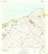
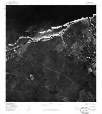 1977 Paia1981 Print · USGSMaui's north shore is captured in the late 1970s through this detailed orthophoto, showing the intersection of coastal life and island agriculture. Researchers can trace the plantation footprints and road networks surrounding Paia, Hamakuapoko, and Puunene.
 - 1977 Map of Wailuku, 1981 Print
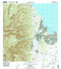
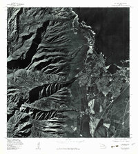 1977 Wailuku1981 Print · USGSMaui's central valley and the dramatic slopes of the West Maui Mountains are captured in detail during the late 1970s. Researchers can trace the development of Wailuku and Kahului alongside landmarks like Iao Valley and the Waihee River.
 - 1983 Map of Paia
 1983 Paia1983 Print · USGSThe northern coast of Maui during the early eighties reveals a landscape shaped by sugar production and coastal development. Genealogists and historians can trace the remnants of the Old Railroad Grade and locate specific sites like Spanish B Village, Maunaolu College, and the Sugar Mill at Puunene.
 - 1983 Map of Wailuku, 1984 Print
 1983 Wailuku1984 Print · USGSMaui's central hub comes to life in the early eighties as the island balanced its industrial roots and growing residential centers. Researchers can trace the layout of Wailuku, locate ancient landmarks like Haleiki Heiau, and find the Battle of Kepaniwai Historical Marker.2 unique versions available
 - 1997 Map of Wailuku, 1999 Print
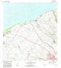
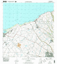
 1997 Wailuku1999 Print · USGSMaui in the late nineties is caught between its plantation roots and modern expansion, centered on the historic seat of Wailuku. Genealogists and historians can trace family locations through McGerrow Village, find the Waiehu Cem, or locate the Wailuku Mill and local schools.
 - 1997 Map of Paia, 1999 Print
 1997 Paia1999 Print · USGSNorth Maui's plantation culture and coastline are captured in the late nineties, showing the transition from sugar fields to community hubs. Researchers can trace the layout of Spanish B Village, the Hamakuapoko Nursery & Gym, and the early footprint of Spreckelsville.
End of results
Showing maps 1-11 of 11
Top cities near Kahului
Top neighborhoods of Kahului
Frequently asked questions
- What are the different types of historical maps available for Kahului?
- What is the oldest map of Kahului?
- Where can I purchase historical maps of Kahului for my home or office?
- Where can I download high-res historical maps of Kahului?
- Are there historical topographic maps available for Kahului?
- Is there historical aerial imagery available for Kahului?
- Where are historical maps of Kahului sourced from?