Old Maps of Kaonoulu, Hawaii for Hiking & Exploration
Hike through history with 9 historic maps of Kaonoulu. Explore old trails, ghost towns, and forgotten backroads — perfect for outdoor adventurers and local explorers.
- Rediscover forgotten places: Map out old mining camps, roads, and footpaths that no longer exist on modern maps.
- Layer with modern tools: Combine with LiDAR or satellite views to plan hikes through historical terrain.
- Made for exploration: Popular among hikers, overlanders, and local history lovers.
Use these maps to find adventure and explore the hidden past of Kaonoulu.
Kaonoulu, HI maps
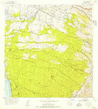
(9)- 1954 Map of Maui
 1954 Maui1954 Print · USGSThe central Hawaiian Islands are shown during the mid-fifties, detailing the agricultural and coastal infrastructure of Maui, Lanai, and Molokai. Genealogists and researchers can trace plantation-era history at Haliimaile Camp, locate old harbors like Kaumalapau Harbor, or explore the early bounds of Haleakala National Park.
 - 1954 Map of Puu O Kali, 1956 Print
 1954 Puu O Kali1956 Print · USGSMaui's leeward slopes are captured in the mid-fifties, showing a detailed network of residential homesteads and sugar-era camps. Genealogists can trace early properties in the Waiakoa Homesteads or locate family sites near Puu Hale Cemetery and Camp K-3.2 unique versions available
 - 1966 Map of Maui
 1966 Maui1966 Print · USGSThe central islands of Maui, Molokai, Lanai, and Kahoolawe are shown in detail during the mid-1960s as plantation life and early tourism coexisted. Genealogists and researchers can trace family locations in old plantation towns like Puunene, the harbor at Lahaina, and Hoolehua on Molokai.
 - 1974 Map of Maui
 1974 Maui1974 Print · USGSMid-century Hawaii is captured here through the detailed landscapes of Maui, Molokai, Lanai, and Kahoolawe as they appeared in the 1970s. Researchers can trace the layout of island hubs like Lahaina and Lanai City alongside remote landmarks like Wainapanapa Cave.2 unique versions available
 - 1983 Map of Puu O Kali, 1984 Print
 1983 Puu O Kali1984 Print · USGSUpcountry Maui in the early eighties reveals a unique landscape of high-elevation homesteads and volcanic terrain. Genealogists and researchers can trace land divisions at Kula Homesteads and find local landmarks like Pau Hele Cemetery and Keokea.
 - 1992 Map of Puu O Kali, 1999 Print
 1992 Puu O Kali1999 Print · USGSThe western slopes of Maui are shown during the early nineties as residential and agricultural subdivisions expand toward the coast. Researchers can trace land grants and water rights through the Waikoa Homesteads and the complex Haiku Ditch irrigation system.
 - 2013 Map of Puu O Kali, 2013 Print
 2013 Puu O Kali2013 Print · USGSCovers Kaonoulu, including Kihei, Keokea, and other nearby areas
 - 2017 Map of Puu O Kali, 2017 Print
 2017 Puu O Kali2017 Print · USGSCovers Kaonoulu, including Kihei, Keokea, and other nearby areas
 - 2024 Map of Puu O Kali, 2024 Print
 2024 Puu O Kali2024 Print · USGSMaui's leeward coast and volcanic uplands are captured here in the early twenty-first century, showing the expansion of coastal communities. Genealogists and researchers can locate Lihue Cem, Puu Hele Cem, and the historic Trinity Episcopal Church By the Sea.
End of results
Showing maps 1-9 of 9
Top cities near Kaonoulu
Frequently asked questions
- What are the different types of historical maps available for Kaonoulu?
- What is the oldest map of Kaonoulu?
- Where can I purchase historical maps of Kaonoulu for my home or office?
- Where can I download high-res historical maps of Kaonoulu?
- Are there historical topographic maps available for Kaonoulu?
- Is there historical aerial imagery available for Kaonoulu?
- Where are historical maps of Kaonoulu sourced from?