Old Maps of Nāhiku, Hawaii for Academic Research
Study the evolution of Nāhiku with 9 high-resolution historic maps. Whether you're teaching, researching, or modeling changes in land use, these maps provide essential visual documentation of urban, environmental, and geographic change.
- Analyze long-term change: Track patterns in development, transportation, and natural features.
- Ideal for environmental or urban studies: Support academic projects with primary historical map data.
- Use in the classroom or lab: Educators and researchers rely on these maps to bring historical context to life.
These maps are a powerful tool for teaching, research, and visualizing how Nāhiku has changed over the decades.
Nāhiku, HI maps
(9)- 1954 Map of Maui
 1954 Maui1954 Print · USGSThe central Hawaiian Islands are shown during the mid-fifties, detailing the agricultural and coastal infrastructure of Maui, Lanai, and Molokai. Genealogists and researchers can trace plantation-era history at Haliimaile Camp, locate old harbors like Kaumalapau Harbor, or explore the early bounds of Haleakala National Park.
 - 1957 Map of Nahiku, 1959 Print
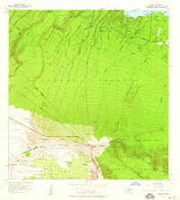 1957 Nahiku1959 Print · USGSThe northeastern coast of Maui is captured here in the late fifties, showing the winding Hana Highway and the remote Nahiku Homesteads. Researchers can trace the water infrastructure of the Koolau Forest Reserve or locate high-elevation landmarks like Waikau Cabin and the Cemetery near Honolulunui Bay.2 unique versions available
 - 1966 Map of Maui
 1966 Maui1966 Print · USGSThe central islands of Maui, Molokai, Lanai, and Kahoolawe are shown in detail during the mid-1960s as plantation life and early tourism coexisted. Genealogists and researchers can trace family locations in old plantation towns like Puunene, the harbor at Lahaina, and Hoolehua on Molokai.
 - 1974 Map of Maui
 1974 Maui1974 Print · USGSMid-century Hawaii is captured here through the detailed landscapes of Maui, Molokai, Lanai, and Kahoolawe as they appeared in the 1970s. Researchers can trace the layout of island hubs like Lahaina and Lanai City alongside remote landmarks like Wainapanapa Cave.2 unique versions available
 - 1983 Map of Nahiku
 1983 Nahiku1983 Print · USGSThe north coast of Maui meets the volcanic heights of Haleakala in the early 1980s. Trace the winding Hana Highway past Nahiku Homesteads or locate backcountry shelters like Kapaloa Cabin and Paliku Cabin.
 - 1992 Map of Nahiku, 2003 Print
 1992 Nahiku2003 Print · USGSCoastal Maui meets the volcanic heights of Haleakalā in the early nineties, showing a landscape of deep valleys and protected reserves. Genealogists and hikers can locate the Nāhiku settlement, coastal cemeteries, and remote landmarks like Paliku Cabin and Kopiliula Falls.
 - 2013 Map of Nahiku, 2013 Print
 2013 Nahiku2013 Print · USGSCovers Nāhiku, including Maui County, United States, and other nearby areas
 - 2017 Map of Nahiku, 2017 Print
 2017 Nahiku2017 Print · USGSCovers Nāhiku, including Maui County, United States, and other nearby areas
 - 2024 Map of Nahiku, 2024 Print
 2024 Nahiku2024 Print · USGSMaui's windward coast and high volcanic interior are captured here in the early twenty-first century, showing the transition from mountain peaks to the sea. Modern researchers can trace backcountry routes like the Sliding Sands Trl or locate coastal sites near Nāhiku and Waiohue Bay.
End of results
Showing maps 1-9 of 9
Frequently asked questions
- What are the different types of historical maps available for Nāhiku?
- What is the oldest map of Nāhiku?
- Where can I purchase historical maps of Nāhiku for my home or office?
- Where can I download high-res historical maps of Nāhiku?
- Are there historical topographic maps available for Nāhiku?
- Is there historical aerial imagery available for Nāhiku?
- Where are historical maps of Nāhiku sourced from?