1970s Maps of Waikapu, Hawaii
Explore 2 historic maps of Waikapu from the 1970s. These maps offer a rare glimpse into what life looked like during the 1970s — showing old roads, neighborhoods, homes, and landmarks that have changed or disappeared over time.
Whether you're researching your family's past, planning a metal detecting trip, or studying how Waikapu's landscape evolved across the 1970s, these high-resolution maps are a powerful tool for exploring the history of this region.
- Focus on a specific era: All maps on this page are from the 1970s, giving you a focused view of this time period.
- See what’s changed: Compare century-old streets, trails, and buildings to today's modern landscape using overlays and satellite layers.
- Research with precision: Use these maps for genealogy, historical research, land use analysis, or educational projects.
- View, download, or print: Maps are fully viewable online in high resolution, and can be downloaded or printed for your own records.
Start exploring Waikapu's history through authentic maps from the 1970s. This is your window into the past.
Waikapu, HI maps
(2)- 1974 Map of Maui
 1974 Maui1974 Print · USGSMid-century Hawaii is captured here through the detailed landscapes of Maui, Molokai, Lanai, and Kahoolawe as they appeared in the 1970s. Researchers can trace the layout of island hubs like Lahaina and Lanai City alongside remote landmarks like Wainapanapa Cave.2 unique versions available
 - 1977 Map of Wailuku, 1981 Print
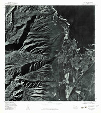 1977 Wailuku1981 Print · USGSMaui's central valley and the dramatic slopes of the West Maui Mountains are captured in detail during the late 1970s. Researchers can trace the development of Wailuku and Kahului alongside landmarks like Iao Valley and the Waihee River.
End of results
Showing maps 1-2 of 2
Top cities near Waikapu
Frequently asked questions
- What are the different types of historical maps available for Waikapu?
- What is the oldest map of Waikapu?
- Where can I purchase historical maps of Waikapu for my home or office?
- Where can I download high-res historical maps of Waikapu?
- Are there historical topographic maps available for Waikapu?
- Is there historical aerial imagery available for Waikapu?
- Where are historical maps of Waikapu sourced from?