1950s Maps of Hidden Springs, Idaho
Explore 5 historic maps of Hidden Springs from the 1950s. These maps offer a rare glimpse into what life looked like during the 1950s — showing old roads, neighborhoods, homes, and landmarks that have changed or disappeared over time.
Whether you're researching your family's past, planning a metal detecting trip, or studying how Hidden Springs's landscape evolved across the 1950s, these high-resolution maps are a powerful tool for exploring the history of this region.
- Focus on a specific era: All maps on this page are from the 1950s, giving you a focused view of this time period.
- See what’s changed: Compare century-old streets, trails, and buildings to today's modern landscape using overlays and satellite layers.
- Research with precision: Use these maps for genealogy, historical research, land use analysis, or educational projects.
- View, download, or print: Maps are fully viewable online in high resolution, and can be downloaded or printed for your own records.
Start exploring Hidden Springs's history through authentic maps from the 1950s. This is your window into the past.
Hidden Springs, ID maps
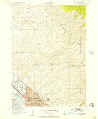
(5)- 1953 Map of Eagle, 1955 Print
 1953 Eagle1955 Print · USGSThe Boise River valley in the early fifties shows a landscape of irrigation canals and early aviation. Genealogists can locate McMillan Chapel, Dry Creek Cem, and several schoolhouses like Green Meadows Sch.5 unique versions available
 - 1954 Map of Boise North, 1957 Print
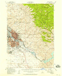
 1954 Boise North1957 Print · USGSBoise and Garden City are captured in the mid-fifties as the city began to climb the foothills and expand along the river. Genealogists and local historians can locate early institutions like the Soldiers Home, Collister Sch, and the Boise City Canal.2 unique versions available
 - 1954 Map of Boise, 1958 Print
 1954 Boise1958 Print · USGSBoise and the surrounding Idaho foothills are captured here in the mid-fifties, just as suburban expansion began meeting the rugged edge of the Boise National Forest. Researchers can trace the Old Oregon Trail, locate the State Penitentiary, and find long-established schools like St Marys Sch.2 unique versions available
 - 1955 Map of Boise, 1977 Print
 1955 Boise1977 Print · USGSThe Treasure Valley and Owyhee uplands are shown in detail during the mid-fifties, capturing the region's transition into a major agricultural and urban hub. Researchers can trace the Union Pacific line through Nampa, explore the volcanic Jordan Craters, or locate the historic mining district of Silver City.
 - 1958 Map of Boise
 1958 Boise1958 Print · USGSThe Treasure Valley and Snake River Plain come alive in the mid-fifties as the rail-and-river economy transitions into a modern agricultural hub. Trace the Union Pacific lines through Nampa or locate remote landmarks like Initial Point and the Rockville settlement.2 unique versions available
End of results
Showing maps 1-5 of 5
Top cities near Hidden Springs
- Boise historical maps
- Meridian historical maps
- Nampa historical maps
- Eagle historical maps
- Kuna historical maps
- Star historical maps
See more
Frequently asked questions
- What are the different types of historical maps available for Hidden Springs?
- What is the oldest map of Hidden Springs?
- Where can I purchase historical maps of Hidden Springs for my home or office?
- Where can I download high-res historical maps of Hidden Springs?
- Are there historical topographic maps available for Hidden Springs?
- Is there historical aerial imagery available for Hidden Springs?
- Where are historical maps of Hidden Springs sourced from?