1950s Maps of Kuna, Idaho
Explore 6 historic maps of Kuna from the 1950s. These maps offer a rare glimpse into what life looked like during the 1950s — showing old roads, neighborhoods, homes, and landmarks that have changed or disappeared over time.
Whether you're researching your family's past, planning a metal detecting trip, or studying how Kuna's landscape evolved across the 1950s, these high-resolution maps are a powerful tool for exploring the history of this region.
- Focus on a specific era: All maps on this page are from the 1950s, giving you a focused view of this time period.
- See what’s changed: Compare century-old streets, trails, and buildings to today's modern landscape using overlays and satellite layers.
- Research with precision: Use these maps for genealogy, historical research, land use analysis, or educational projects.
- View, download, or print: Maps are fully viewable online in high resolution, and can be downloaded or printed for your own records.
Start exploring Kuna's history through authentic maps from the 1950s. This is your window into the past.
Kuna, ID maps
(6)- 1953 Map of Cloverdale, 1955 Print
 1953 Cloverdale1955 Print · USGSAda County in the early fifties is shown here as a productive landscape of family farms and irrigation canals. Genealogists can trace rural life through numerous district schools like Hillsdale Sch and landmarks like the Tenmile Rodeo Grounds or Cloverdale Memorial Park.4 unique versions available
 - 1953 Map of Meridian, 1955 Print
 1953 Meridian1955 Print · USGSThe town of Meridian serves as a hub for the Boise Valley's irrigation network in the early fifties. Local historians can trace the development of rural education and industry through landmarks like Columbia School, Amity Sch, and the Union Pacific Railroad.4 unique versions available
 - 1955 Map of Boise, 1977 Print
 1955 Boise1977 Print · USGSThe Treasure Valley and Owyhee uplands are shown in detail during the mid-fifties, capturing the region's transition into a major agricultural and urban hub. Researchers can trace the Union Pacific line through Nampa, explore the volcanic Jordan Craters, or locate the historic mining district of Silver City.
 - 1958 Map of Boise
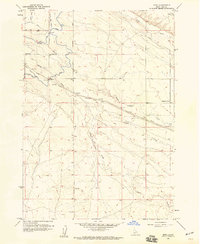
 1958 Boise1958 Print · USGSThe Treasure Valley and Snake River Plain come alive in the mid-fifties as the rail-and-river economy transitions into a modern agricultural hub. Trace the Union Pacific lines through Nampa or locate remote landmarks like Initial Point and the Rockville settlement.2 unique versions available
 - 1958 Map of Kuna, 1959 Print
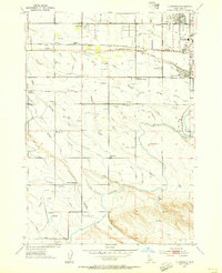
 1958 Kuna1959 Print · USGSAgricultural expansion in southern Ada County is documented here during the late fifties as irrigation transformed the high desert. Researchers can trace the path of the Oregon Short Line Railroad and find local landmarks like Kuna Cave, the town Cem, and Kuna Butte.3 unique versions available
 - 1958 Map of Mora, 1959 Print
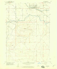
 1958 Mora1959 Print · USGSAda County’s high desert plains in the late fifties show a landscape defined by the intersection of the Union Pacific (Oregon Short Line) Railroad and irrigation works. Researchers can trace the water network from the Mason Creek Feeder to the Kuna Canal or locate the small settlement of Mora.3 unique versions available
End of results
Showing maps 1-6 of 6
Top cities near Kuna
- Boise historical maps
- Meridian historical maps
- Nampa historical maps
- Caldwell historical maps
- Eagle historical maps
- Star historical maps
See more
Top neighborhoods of Kuna
Frequently asked questions
- What are the different types of historical maps available for Kuna?
- What is the oldest map of Kuna?
- Where can I purchase historical maps of Kuna for my home or office?
- Where can I download high-res historical maps of Kuna?
- Are there historical topographic maps available for Kuna?
- Is there historical aerial imagery available for Kuna?
- Where are historical maps of Kuna sourced from?