1990s Maps of Kuna, Idaho
Explore 3 historic maps of Kuna from the 1990s. These maps offer a rare glimpse into what life looked like during the 1990s — showing old roads, neighborhoods, homes, and landmarks that have changed or disappeared over time.
Whether you're researching your family's past, planning a metal detecting trip, or studying how Kuna's landscape evolved across the 1990s, these high-resolution maps are a powerful tool for exploring the history of this region.
- Focus on a specific era: All maps on this page are from the 1990s, giving you a focused view of this time period.
- See what’s changed: Compare century-old streets, trails, and buildings to today's modern landscape using overlays and satellite layers.
- Research with precision: Use these maps for genealogy, historical research, land use analysis, or educational projects.
- View, download, or print: Maps are fully viewable online in high resolution, and can be downloaded or printed for your own records.
Start exploring Kuna's history through authentic maps from the 1990s. This is your window into the past.
Kuna, ID maps
(3)- 1992 Map of Mora
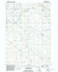 1992 Mora1992 Print · USGSAda County in the early nineties shows the intersection of high-desert conservation and extensive irrigation. Genealogists and local historians can trace the rural layouts of Mora and Pleasant Valley or locate the Idaho State Correctional Institution.
 - 1992 Map of Kuna
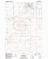 1992 Kuna1992 Print · USGSKuna and the surrounding High Desert are captured here in the early nineties as irrigation transformed the sagebrush steppe. Researchers can trace the path of the New York Canal and locate landmarks like Kuna Cave and Hubbard Sch.
 - 1998 Map of Cloverdale, 2002 Print
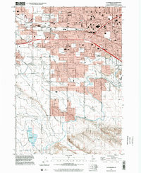 1998 Cloverdale2002 Print · USGSThe Boise and Meridian borderlands come into focus during the late nineties as residential growth meets the valley's irrigation network. Genealogists and historians can locate Cloverdale Mem. Park (Cem) and legacy schools like Cole Sch and Locust Grove Sch.
End of results
Showing maps 1-3 of 3
Top cities near Kuna
- Boise historical maps
- Meridian historical maps
- Nampa historical maps
- Caldwell historical maps
- Eagle historical maps
- Star historical maps
See more
Top neighborhoods of Kuna
Frequently asked questions
- What are the different types of historical maps available for Kuna?
- What is the oldest map of Kuna?
- Where can I purchase historical maps of Kuna for my home or office?
- Where can I download high-res historical maps of Kuna?
- Are there historical topographic maps available for Kuna?
- Is there historical aerial imagery available for Kuna?
- Where are historical maps of Kuna sourced from?