1900s (20th Century) Maps of Cuprum, Idaho
Explore 6 historic maps of Cuprum from the 1900s (20th Century). These maps offer a rare glimpse into what life looked like during the 1900s — showing old roads, neighborhoods, homes, and landmarks that have changed or disappeared over time.
Whether you're researching your family's past, planning a metal detecting trip, or studying how Cuprum's landscape evolved across the 1900s, these high-resolution maps are a powerful tool for exploring the history of this region.
- Focus on a specific era: All maps on this page are from the 1900s, giving you a focused view of this time period.
- See what’s changed: Compare century-old streets, trails, and buildings to today's modern landscape using overlays and satellite layers.
- Research with precision: Use these maps for genealogy, historical research, land use analysis, or educational projects.
- View, download, or print: Maps are fully viewable online in high resolution, and can be downloaded or printed for your own records.
Start exploring Cuprum's history through authentic maps from the 1900s. This is your window into the past.
Cuprum, ID maps
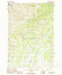
(6)- 1920 Map of Seven Devils Mining District
 1920 Seven Devils Mining District1920 Print · USGSThe Seven Devils Mining District was a bustling area of extraction and high-country ranching in the 1920s. Genealogists and historians can trace old homesteads and mining hubs like Cuprum, Landore, and Towsley Cabin, or locate the Landore School and Iron Springs Ranger Sta.
 - 1955 Map of Grangeville, 1964 Print
 1955 Grangeville1964 Print · USGSThe high country of the Idaho-Oregon border comes alive in the mid-1950s, showing the deep river canyons and mountain peaks. Trace the Union Pacific RR through the valleys or locate settlements like Grangeville, Joseph, and the shoreline of Wallowa Lake.4 unique versions available
 - 1957 Map of Cuprum, 1958 Print
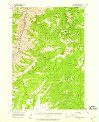 1957 Cuprum1958 Print · USGSThe Seven Devils Mountains of Idaho are captured here during the 1950s, showing the intersection of forest management and declining copper mining. Genealogists and historians can locate old mining sites like Bluejacket Mine and the remnants of former settlements at Landore and Helena.3 unique versions available
 - 1959 Map of Grangeville
 1959 Grangeville1959 Print · USGSThe high alpine peaks and deep river canyons of the Idaho-Oregon borderlands are captured in the late fifties. Researchers can trace the Union Pacific RR through the valleys to settlements like Enterprise, Union, and Grangeville.2 unique versions available
 - 1987 Map of Riggins
 1987 Riggins1987 Print · USGSThe Salmon and Snake River canyons defined the Idaho-Oregon borderlands in the 1980s as wilderness recreation and historic mining sites overlapped. Researchers can trace the rugged access to Riggins, find high-altitude camps near Hazard Lake, and locate the Florence Mine or Black Bear Mine.
 - 1990 Map of Cuprum
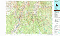
 1990 Cuprum1990 Print · USGSAdams County in the 1990s reveals a landscape of high-country mining camps and remote forest outposts along the Snake River. Genealogists and researchers can pinpoint former settlement locations at Landore (Site) and Decorah (Site) or trace the Copper Cliff Mine.
End of results
Showing maps 1-6 of 6
Frequently asked questions
- What are the different types of historical maps available for Cuprum?
- What is the oldest map of Cuprum?
- Where can I purchase historical maps of Cuprum for my home or office?
- Where can I download high-res historical maps of Cuprum?
- Are there historical topographic maps available for Cuprum?
- Is there historical aerial imagery available for Cuprum?
- Where are historical maps of Cuprum sourced from?