1960s Maps of Dingle, Idaho
Explore 2 historic maps of Dingle from the 1960s. These maps offer a rare glimpse into what life looked like during the 1960s — showing old roads, neighborhoods, homes, and landmarks that have changed or disappeared over time.
Whether you're researching your family's past, planning a metal detecting trip, or studying how Dingle's landscape evolved across the 1960s, these high-resolution maps are a powerful tool for exploring the history of this region.
- Focus on a specific era: All maps on this page are from the 1960s, giving you a focused view of this time period.
- See what’s changed: Compare century-old streets, trails, and buildings to today's modern landscape using overlays and satellite layers.
- Research with precision: Use these maps for genealogy, historical research, land use analysis, or educational projects.
- View, download, or print: Maps are fully viewable online in high resolution, and can be downloaded or printed for your own records.
Start exploring Dingle's history through authentic maps from the 1960s. This is your window into the past.
Dingle, ID maps
(2)- 1962 Map of Preston
 1962 Preston1962 Print · USGSSoutheast Idaho and the Wyoming borderlands are captured here in the early sixties, a time of thriving agricultural valleys and mountain ranching. Researchers can trace the Union Pacific rail lines and find legacy settlements like Montpelier, Afton, and Preston.
 - 1967 Map of Dingle, 1969 Print
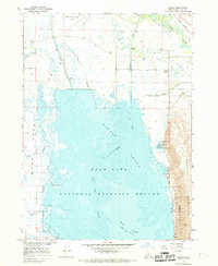 1967 Dingle1969 Print · USGSBear Lake Valley in the late sixties reveals an intricate network of irrigation and wildlife conservation across the Idaho wetlands. Genealogists and historians can trace family sites near Dingle, the Dingle Cem, and the shifting waters of Merkley Lake.2 unique versions available
End of results
Showing maps 1-2 of 2
Top cities near Dingle
Frequently asked questions
- What are the different types of historical maps available for Dingle?
- What is the oldest map of Dingle?
- Where can I purchase historical maps of Dingle for my home or office?
- Where can I download high-res historical maps of Dingle?
- Are there historical topographic maps available for Dingle?
- Is there historical aerial imagery available for Dingle?
- Where are historical maps of Dingle sourced from?