Old Maps of Bear Lake County, Idaho
Explore 208 old maps of Bear Lake County, spanning from 1909 to today. These high-resolution historic maps reveal how streets, neighborhoods, landmarks, and natural features evolved over time — perfect for genealogy, metal detecting, research, and local history exploration.
What you can do with these maps:
- See how Bear Lake County changed over time: Compare historical maps to modern-day views to trace roads, homesites, rail lines & more.
- View detailed metadata: Each map includes creators, publishers, year, scale, and archive source.
- Overlay maps with satellite & LiDAR: Visualize the past alongside modern tools to explore terrain & human change.
- Trusted historical sources: Maps sourced from the USGS, Library of Congress, and other archives.
- Access maps your way: View online, download high-res files, or order prints for personal or research use.
Start exploring old maps of Bear Lake County to uncover forgotten places, hidden landmarks, and the deep history beneath your feet.
Bear Lake County, ID maps
(208)- 1909 Map of Montpelier, 1957 Print
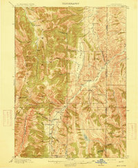
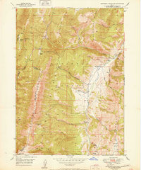
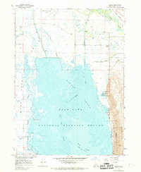
 1909 Montpelier1957 Print · USGSBear Lake County at the turn of the century shows a landscape defined by the arrival of the Oregon Short Line RR and early irrigation. Researchers can trace the original footprints of Montpelier and Paris or locate the historic Hot Springs Turnpike along the lake's eastern shore.
 - 1911 Map of Montpelier
 1911 Montpelier1911 Print · USGSThe Bear Lake Valley at the start of the twentieth century was a vital rail and ranching corridor. Trace the Oregon Short Line RR through Montpelier and Paris, or locate early lakeside settlements like Fish Haven and St Charles.3 unique versions available
 - 1911 Map of Slug Creek, 1958 Print
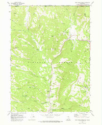
 1911 Slug Creek1958 Print · USGSSoutheast Idaho ranching and rail infrastructure are frozen in time just after the turn of the century. Genealogists can trace family homesteads like Stark and Strong Ranch and Schmid's Ranch or follow the path of the Oregon Short Line Railroad.
 - 1912 Map of Randolph
 1912 Randolph1912 Print · USGSThe high valley ranching country of the Utah-Wyoming border is captured here in the early twentieth century. Genealogists and historians can trace family land holdings such as Rex Ranch or Sixmile Ranch and find old routes like the Ogden Road.3 unique versions available
 - 1914 Map of Logan, 1957 Print
 1914 Logan1957 Print · USGSCache Valley thrives in the early nineteen-hundreds as a hub of rail travel and sugar beet processing. Genealogists can locate family homesteads near Stephenson School, trace the Oregon Short Line, or find remote operations like the Amazon Mine.
 - 1915 Map of Preston
 1915 Preston1915 Print · USGSSoutheastern Idaho and northern Utah are defined by their river valleys and early irrigation networks during the mid-1910s. Genealogists can locate family landmarks like the Thatcher Meetinghouse, Egypt School, and the path of the Oregon Short Line.2 unique versions available
 - 1915 Map of Crow Creek
 1915 Crow Creek1915 Print · USGSThe high-desert ranching and salt industries of the Idaho-Wyoming border are captured here just before World War I. Researchers can locate early family homesteads like Cozzens Ranch and Books Ranch, or trace the operations at the Old Salt Works.3 unique versions available
 - 1916 Map of Logan
 1916 Logan1916 Print · USGSCache Valley and the northern Wasatch Range come alive in this mid-1910s survey, showing the peak of the local rail-and-sugar economy. Genealogists can locate family holdings like Hardware Ranch, early rural sites like Stephenson School, and the industrial Sugar Factory.4 unique versions available
 - 1918 Map of Preston
 1918 Preston1918 Print · USGSSouthern Idaho and northern Utah are captured just before the close of the Great War, showing a landscape of burgeoning farm towns and irrigation canals. Researchers can trace the Oregon Short Line to early settlements like Preston or locate rural landmarks like the Thatcher Meetinghouse and Egypt School.2 unique versions available
 - 1948 Map of Soda Springs, 1965 Print
 1948 Soda Springs1965 Print · USGSSoda Springs and the surrounding Bear River valley are captured in the late 1940s, showing a landscape shaped by the historic Oregon Trail and modern industry. Genealogists and historians can locate the Grace Cem, Eightmile Sch, and the workings of the Conda Mine and Idaho Sulphur Mine (Aband).2 unique versions available
 - 1949 Map of Soda Springs
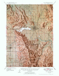 1949 Soda Springs1949 Print · USGSSoda Springs and the surrounding Bear River valley are captured in the late 1940s, a landscape defined by volcanic geology and phosphate mining. Researchers can locate specific pioneer-era sites like the Wagonbox Grave, Eightmile School, and the Conda Mine.4 unique versions available
 - 1949 Map of Snowdrift Mountain, 1963 Print
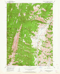 1949 Snowdrift Mountain1963 Print · USGSCaribou and Bear Lake counties were defined by remote ranching outposts and high forest divides during the late 1940s. Researchers can locate family-named sites like Nate Ranch and Allemans Ranch or trace the Great Basin Divide across Snowdrift Mountain.3 unique versions available
 - 1951 Map of Snowdrift Mountain
 1951 Snowdrift Mountain1951 Print · USGSCaribou County and Bear Lake County meet in this high-altitude corner of Idaho during the early postwar years. Genealogists and historians can trace old homestead sites and forest stations like Nate Ranch, Allemans Ranch, and the Halfway House.
 - 1954 Map of Ogden, 1967 Print
 1954 Ogden1967 Print · USGSThe northern Utah corridor and Wyoming borderlands are captured here in the mid-1950s, showing the region's transition from mountain wilderness to settled valleys. Researchers can trace historic institutions like Utah State University or locate vanished points like Church Butte Station and the Trappist Monastery.3 unique versions available
 - 1955 Map of Preston, 1968 Print
 1955 Preston1968 Print · USGSSoutheast Idaho and western Wyoming are shown in detail during the mid-fifties, from the high Bear River Range to the Green River Basin. Genealogists and collectors can trace the Union Pacific RR through historic towns like Preston, Montpelier, and Afton.3 unique versions available
 - 1958 Map of Ogden
 1958 Ogden1958 Print · USGSNorthern Utah and southwestern Wyoming are captured here during a period of steady growth and military expansion. You can trace the Union Pacific rail lines and early road networks connecting Ogden and Logan to Bear Lake and Evanston.
 - 1958 Map of Preston
 1958 Preston1958 Print · USGSThe high valleys of the Idaho and Wyoming borderlands are captured here in the late fifties, showcasing a landscape of mountain ranching and phosphate mining. Genealogists and historians can locate early settlements like Chesterfield and Bedford or trace the Union Pacific rail lines serving Cokeville.2 unique versions available
 - 1960 Map of Ogden
 1960 Ogden1960 Print · USGSIn the mid-1950s, this region of the American West balanced military expansion with frontier history along the Union Pacific RR. Genealogists and historians can trace old settlements like Fort Bridger, the residential growth of Washington Terrace, and industrial sites from the Hill AFB complex to the coal mines of Kemmerer.
 - 1962 Map of Preston
 1962 Preston1962 Print · USGSSoutheast Idaho and the Wyoming borderlands are captured here in the early sixties, a time of thriving agricultural valleys and mountain ranching. Researchers can trace the Union Pacific rail lines and find legacy settlements like Montpelier, Afton, and Preston.
 - 1967 Map of Montpelier, 1968 Print
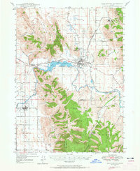
 1967 Montpelier1968 Print · USGSIn the late 1960s, the Bear Lake Valley was a hub of rail transport and regional commerce centered on the town of Montpelier. Researchers can trace the civic footprint of the town and locate rural landmarks like the Winters Sch, the Rainbow Dam, and Wardboro.2 unique versions available
 - 1967 Map of Paris, 1968 Print
 1967 Paris1968 Print · USGSThe Bear Lake Valley villages of Paris and Bloomington are shown here in the late 1960s, poised between the lakeshore and the forest. Researchers can trace family-named sites and infrastructure like Emerson Sch, the Boulder Mine, and the OLD RAILROAD GRADE.3 unique versions available
 - 1967 Map of Ovid, 1968 Print
 1967 Ovid1968 Print · USGSBear Lake County's valley floor and mountain slopes are captured in the late sixties, showing a landscape defined by small ranching communities and old transit lines. Genealogists and historians can locate family sites near Ovid, trace the Old Railroad Grade, and find burials at Liberty Cem.
 - 1967 Map of Dingle, 1969 Print
 1967 Dingle1969 Print · USGSBear Lake Valley in the late sixties reveals an intricate network of irrigation and wildlife conservation across the Idaho wetlands. Genealogists and historians can trace family sites near Dingle, the Dingle Cem, and the shifting waters of Merkley Lake.2 unique versions available
 - 1969 Map of Tony Grove Creek, 1973 Print
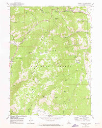
 1969 Tony Grove Creek1973 Print · USGSHigh in the Cache National Forest during the late sixties, this survey captures the intersection of mountainous recreation and resource history. Trace the trails leading to the Amazon Mine, explore the Beaver Mtn Ski Area, or locate the Tony Grove Memorial Guard Station.
 - 1969 Map of Midnight Mtn, 1973 Print
 1969 Midnight Mtn1973 Print · USGSThe Bear Lake Range in the late sixties reveals a landscape of high-country basins and deep canyons along the Bear Lake and Franklin county line. Trace historic routes via the PACK TRAIL and JEEP TRAIL to remote landmarks like Midnight Mtn, Midnight Lake, and Danish Flat.
Showing maps 1-25 of 208
Top cities of Bear Lake County
- Montpelier historical maps
- Paris historical maps
- Georgetown historical maps
- Bloomington historical maps
Frequently asked questions
- What are the different types of historical maps available for Bear Lake County?
- What is the oldest map of Bear Lake County?
- Where can I purchase historical maps of Bear Lake County for my home or office?
- Where can I download high-res historical maps of Bear Lake County?
- Are there historical topographic maps available for Bear Lake County?
- Is there historical aerial imagery available for Bear Lake County?
- Where are historical maps of Bear Lake County sourced from?