1990s Maps of Shelley, Idaho
Explore 1 historic maps of Shelley from the 1990s. These maps offer a rare glimpse into what life looked like during the 1990s — showing old roads, neighborhoods, homes, and landmarks that have changed or disappeared over time.
Whether you're researching your family's past, planning a metal detecting trip, or studying how Shelley's landscape evolved across the 1990s, these high-resolution maps are a powerful tool for exploring the history of this region.
- Focus on a specific era: All maps on this page are from the 1990s, giving you a focused view of this time period.
- See what’s changed: Compare century-old streets, trails, and buildings to today's modern landscape using overlays and satellite layers.
- Research with precision: Use these maps for genealogy, historical research, land use analysis, or educational projects.
- View, download, or print: Maps are fully viewable online in high resolution, and can be downloaded or printed for your own records.
Start exploring Shelley's history through authentic maps from the 1990s. This is your window into the past.
Shelley, ID maps
(1)- 1998 Map of Goshen, 2002 Print
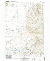 1998 Goshen2002 Print · USGSBingham County and Bonneville County meet here at the close of the twentieth century, where irrigation canals transform the high desert into fertile farmland. Local historians can trace early community sites like Goshen and Shelley, or locate the Jamestown Sch and landmarks within the Fort Indian Hall Indian Reservation.
End of results
Showing maps 1-1 of 1
Top cities near Shelley
- Idaho Falls historical maps
- Ammon historical maps
- Blackfoot historical maps
- Iona historical maps
- Ucon historical maps
- Firth historical maps
See more
Frequently asked questions
- What are the different types of historical maps available for Shelley?
- What is the oldest map of Shelley?
- Where can I purchase historical maps of Shelley for my home or office?
- Where can I download high-res historical maps of Shelley?
- Are there historical topographic maps available for Shelley?
- Is there historical aerial imagery available for Shelley?
- Where are historical maps of Shelley sourced from?