1970s Maps of Carey, Idaho
Explore 2 historic maps of Carey from the 1970s. These maps offer a rare glimpse into what life looked like during the 1970s — showing old roads, neighborhoods, homes, and landmarks that have changed or disappeared over time.
Whether you're researching your family's past, planning a metal detecting trip, or studying how Carey's landscape evolved across the 1970s, these high-resolution maps are a powerful tool for exploring the history of this region.
- Focus on a specific era: All maps on this page are from the 1970s, giving you a focused view of this time period.
- See what’s changed: Compare century-old streets, trails, and buildings to today's modern landscape using overlays and satellite layers.
- Research with precision: Use these maps for genealogy, historical research, land use analysis, or educational projects.
- View, download, or print: Maps are fully viewable online in high resolution, and can be downloaded or printed for your own records.
Start exploring Carey's history through authentic maps from the 1970s. This is your window into the past.
Carey, ID maps
(2)- 1978 Map of Craters Of The Moon
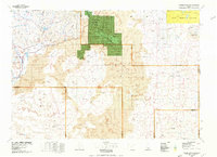 1978 Craters Of The Moon1978 Print · USGSSouthern Idaho in the late seventies revealed a landscape of volcanic fields and pioneer trails where the High Desert meets the mountains. Researchers can trace the path of Goodale's Cutoff past Big Southern Butte or locate remote landmarks like Laidlaw Corrals.
 - 1979 Map of Carey, 1980 Print
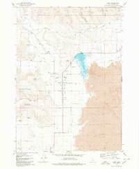 1979 Carey1980 Print · USGSCarey sat at the intersection of irrigation and volcanic desert in the late 1970s. Local researchers can trace family landmarks like Hot Springs Ranch, locate the Carey Cemetery, or study the early layout of the County Fairgrounds and High Sch.
End of results
Showing maps 1-2 of 2
Frequently asked questions
- What are the different types of historical maps available for Carey?
- What is the oldest map of Carey?
- Where can I purchase historical maps of Carey for my home or office?
- Where can I download high-res historical maps of Carey?
- Are there historical topographic maps available for Carey?
- Is there historical aerial imagery available for Carey?
- Where are historical maps of Carey sourced from?