1978 Map of Craters Of The Moon
USGS Topo · Published 1978About this map
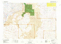
The Great Rift and its volcanic legacy dominate this landscape, showcasing the geological character of south-central Idaho. Centered on the Craters of the Moon National Monument and the adjacent Craters of the Moon Wilderness, the map reveals a vast expanse of basaltic lava flows punctuated by features such as Bowl Crater and Snowdrift Crater. To the northwest, the Pioneer Mountains provide a dramatic contrast to the flat volcanic plains, with drainages like Muldoon Creek and Fish Creek feeding into the Fish Creek Reservoir. This 1978 edition illustrates the intersection of preservation and utility, showing the Idaho National Engineering Laboratory to the northeast while tracing the historic route of Goodale's Cutoff. Small nodes of human activity like Carey and Laidlaw Corrals appear at the edges of the volcanic fields, highlighting how topography has long dictated travel and settlement in this corner of the state.
Find a feature on this map
72 named features on this map. Tap any name to fly to it.
Don’t see what you’re looking for? This feature index may not catch every label — zoom into the map to look around manually.
Map Details
Editions of this 1978 Craters Of The Moon Map
This is the sole edition of this map. No revisions or reprints were ever made.
Other maps of this area

1895 · Hailey
USGS Topo · 1:125,000

1897 · Hailey
USGS Topo · 1:125,000

1934 · American Falls
USGS Topo · 1:62,500

1935 · MacKay
USGS Topo · 1:96,000

1936 · American Falls
USGS Topo · 1:62,500

1954 · Pocatello
USGS Topo · 1:250,000

1955 · Idaho Falls
USGS Topo · 1:250,000

1955 · Twin Falls
USGS Topo · 1:250,000

1955 · Hailey
USGS Topo · 1:250,000

1958 · Twin Falls
USGS Topo · 1:250,000