1970s Maps of Grandjean, Idaho
Explore 1 historic maps of Grandjean from the 1970s. These maps offer a rare glimpse into what life looked like during the 1970s — showing old roads, neighborhoods, homes, and landmarks that have changed or disappeared over time.
Whether you're researching your family's past, planning a metal detecting trip, or studying how Grandjean's landscape evolved across the 1970s, these high-resolution maps are a powerful tool for exploring the history of this region.
- Focus on a specific era: All maps on this page are from the 1970s, giving you a focused view of this time period.
- See what’s changed: Compare century-old streets, trails, and buildings to today's modern landscape using overlays and satellite layers.
- Research with precision: Use these maps for genealogy, historical research, land use analysis, or educational projects.
- View, download, or print: Maps are fully viewable online in high resolution, and can be downloaded or printed for your own records.
Start exploring Grandjean's history through authentic maps from the 1970s. This is your window into the past.
Grandjean, ID maps
(1)- 1972 Map of Grandjean, 1976 Print
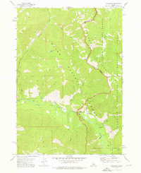 1972 Grandjean1976 Print · USGSThe Sawtooth mountains of the early seventies come alive in this survey of the river valleys and high alpine lakes near the Boise and Challis border. Trace the primitive infrastructure of the day, from the Forest Service Station at Grandjean to Sacajawea Hot Springs and the network of Pack Trails.3 unique versions available
End of results
Showing maps 1-1 of 1
Top cities near Grandjean
Frequently asked questions
- What are the different types of historical maps available for Grandjean?
- What is the oldest map of Grandjean?
- Where can I purchase historical maps of Grandjean for my home or office?
- Where can I download high-res historical maps of Grandjean?
- Are there historical topographic maps available for Grandjean?
- Is there historical aerial imagery available for Grandjean?
- Where are historical maps of Grandjean sourced from?