1940s Maps of Broten, Idaho
Explore 1 historic maps of Broten from the 1940s. These maps offer a rare glimpse into what life looked like during the 1940s — showing old roads, neighborhoods, homes, and landmarks that have changed or disappeared over time.
Whether you're researching your family's past, planning a metal detecting trip, or studying how Broten's landscape evolved across the 1940s, these high-resolution maps are a powerful tool for exploring the history of this region.
- Focus on a specific era: All maps on this page are from the 1940s, giving you a focused view of this time period.
- See what’s changed: Compare century-old streets, trails, and buildings to today's modern landscape using overlays and satellite layers.
- Research with precision: Use these maps for genealogy, historical research, land use analysis, or educational projects.
- View, download, or print: Maps are fully viewable online in high resolution, and can be downloaded or printed for your own records.
Start exploring Broten's history through authentic maps from the 1940s. This is your window into the past.
Broten, ID maps
(1)- 1949 Map of Packsaddle Mtn, 1959 Print
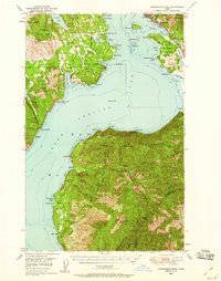 1949 Packsaddle Mtn1959 Print · USGSLake Pend Oreille and the surrounding national forests are captured here in the late 1940s as rail and mining operations shaped the rugged terrain. Genealogists and historians can locate old post offices like Broten PO and remote sites such as Whisky Rock or the Green Monarch Mine.3 unique versions available
End of results
Showing maps 1-1 of 1
Top cities near Broten
- Sandpoint historical maps
- Ponderay historical maps
- Dover historical maps
- Kootenai historical maps
- East Hope historical maps
- Hope historical maps
Frequently asked questions
- What are the different types of historical maps available for Broten?
- What is the oldest map of Broten?
- Where can I purchase historical maps of Broten for my home or office?
- Where can I download high-res historical maps of Broten?
- Are there historical topographic maps available for Broten?
- Is there historical aerial imagery available for Broten?
- Where are historical maps of Broten sourced from?