1970s Maps of Arco, Idaho
Explore 2 historic maps of Arco from the 1970s. These maps offer a rare glimpse into what life looked like during the 1970s — showing old roads, neighborhoods, homes, and landmarks that have changed or disappeared over time.
Whether you're researching your family's past, planning a metal detecting trip, or studying how Arco's landscape evolved across the 1970s, these high-resolution maps are a powerful tool for exploring the history of this region.
- Focus on a specific era: All maps on this page are from the 1970s, giving you a focused view of this time period.
- See what’s changed: Compare century-old streets, trails, and buildings to today's modern landscape using overlays and satellite layers.
- Research with precision: Use these maps for genealogy, historical research, land use analysis, or educational projects.
- View, download, or print: Maps are fully viewable online in high resolution, and can be downloaded or printed for your own records.
Start exploring Arco's history through authentic maps from the 1970s. This is your window into the past.
Arco, ID maps
(2)- 1972 Map of Arco North, 1976 Print
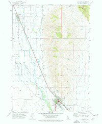 1972 Arco North1976 Print · USGSButte County ranching and irrigation are in focus during the early seventies as the desert valley meets the forest edge. Local historians can trace the Union Pacific rail corridor and find landmarks like the Butte Co High Sch, Hillcrest Cem, and the Natural Arch within the Challis National Forest.
 - 1972 Map of Arco South, 1976 Print
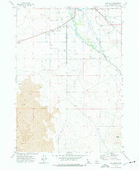 1972 Arco South1976 Print · USGSThe high desert landscape of Idaho's Butte County was a study in water and volcanic rock in the early seventies. Trace the Union Pacific rail corridor near Arco or follow irrigation landmarks like the Big Lost River and the Siphon.
End of results
Showing maps 1-2 of 2
Top cities near Arco
Frequently asked questions
- What are the different types of historical maps available for Arco?
- What is the oldest map of Arco?
- Where can I purchase historical maps of Arco for my home or office?
- Where can I download high-res historical maps of Arco?
- Are there historical topographic maps available for Arco?
- Is there historical aerial imagery available for Arco?
- Where are historical maps of Arco sourced from?