1940s Maps of Grace, Idaho
Explore 2 historic maps of Grace from the 1940s. These maps offer a rare glimpse into what life looked like during the 1940s — showing old roads, neighborhoods, homes, and landmarks that have changed or disappeared over time.
Whether you're researching your family's past, planning a metal detecting trip, or studying how Grace's landscape evolved across the 1940s, these high-resolution maps are a powerful tool for exploring the history of this region.
- Focus on a specific era: All maps on this page are from the 1940s, giving you a focused view of this time period.
- See what’s changed: Compare century-old streets, trails, and buildings to today's modern landscape using overlays and satellite layers.
- Research with precision: Use these maps for genealogy, historical research, land use analysis, or educational projects.
- View, download, or print: Maps are fully viewable online in high resolution, and can be downloaded or printed for your own records.
Start exploring Grace's history through authentic maps from the 1940s. This is your window into the past.
Grace, ID maps
(2)- 1948 Map of Soda Springs, 1965 Print
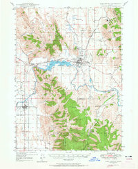 1948 Soda Springs1965 Print · USGSSoda Springs and the surrounding Bear River valley are captured in the late 1940s, showing a landscape shaped by the historic Oregon Trail and modern industry. Genealogists and historians can locate the Grace Cem, Eightmile Sch, and the workings of the Conda Mine and Idaho Sulphur Mine (Aband).2 unique versions available
 - 1949 Map of Soda Springs
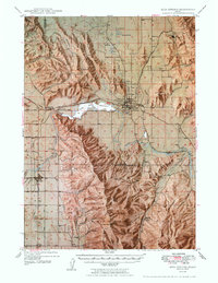 1949 Soda Springs1949 Print · USGSSoda Springs and the surrounding Bear River valley are captured in the late 1940s, a landscape defined by volcanic geology and phosphate mining. Researchers can locate specific pioneer-era sites like the Wagonbox Grave, Eightmile School, and the Conda Mine.4 unique versions available
End of results
Showing maps 1-2 of 2
Top cities near Grace
Frequently asked questions
- What are the different types of historical maps available for Grace?
- What is the oldest map of Grace?
- Where can I purchase historical maps of Grace for my home or office?
- Where can I download high-res historical maps of Grace?
- Are there historical topographic maps available for Grace?
- Is there historical aerial imagery available for Grace?
- Where are historical maps of Grace sourced from?