1980s Maps of Soda Springs, Idaho
Explore 2 historic maps of Soda Springs from the 1980s. These maps offer a rare glimpse into what life looked like during the 1980s — showing old roads, neighborhoods, homes, and landmarks that have changed or disappeared over time.
Whether you're researching your family's past, planning a metal detecting trip, or studying how Soda Springs's landscape evolved across the 1980s, these high-resolution maps are a powerful tool for exploring the history of this region.
- Focus on a specific era: All maps on this page are from the 1980s, giving you a focused view of this time period.
- See what’s changed: Compare century-old streets, trails, and buildings to today's modern landscape using overlays and satellite layers.
- Research with precision: Use these maps for genealogy, historical research, land use analysis, or educational projects.
- View, download, or print: Maps are fully viewable online in high resolution, and can be downloaded or printed for your own records.
Start exploring Soda Springs's history through authentic maps from the 1980s. This is your window into the past.
Soda Springs, ID maps
(2)- 1982 Map of Soda Springs
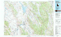 1982 Soda Springs1982 Print · USGSSoutheast Idaho and the Wyoming borderlands come alive in the early eighties as a landscape of mountain ranges and industrial valleys. Genealogists and historians can locate remote family plots like Lund Cem or trace the early paths through Fivemile Meadows and the Fort Hall Indian Reservation.2 unique versions available
 - 1982 Map of Soda Springs
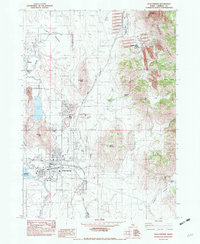 1982 Soda Springs1982 Print · USGSIn the early eighties, Soda Springs was a bustling center of phosphate processing and rail activity along the Union Pacific. Genealogists and historians can trace the mining footprint at Conda or locate the historic Idaho Sulphur Mine and the waters of Hooper Spring.
End of results
Showing maps 1-2 of 2
Top cities near Soda Springs
Frequently asked questions
- What are the different types of historical maps available for Soda Springs?
- What is the oldest map of Soda Springs?
- Where can I purchase historical maps of Soda Springs for my home or office?
- Where can I download high-res historical maps of Soda Springs?
- Are there historical topographic maps available for Soda Springs?
- Is there historical aerial imagery available for Soda Springs?
- Where are historical maps of Soda Springs sourced from?