1900s (20th Century) Maps of Declo, Idaho
Explore 5 historic maps of Declo from the 1900s (20th Century). These maps offer a rare glimpse into what life looked like during the 1900s — showing old roads, neighborhoods, homes, and landmarks that have changed or disappeared over time.
Whether you're researching your family's past, planning a metal detecting trip, or studying how Declo's landscape evolved across the 1900s, these high-resolution maps are a powerful tool for exploring the history of this region.
- Focus on a specific era: All maps on this page are from the 1900s, giving you a focused view of this time period.
- See what’s changed: Compare century-old streets, trails, and buildings to today's modern landscape using overlays and satellite layers.
- Research with precision: Use these maps for genealogy, historical research, land use analysis, or educational projects.
- View, download, or print: Maps are fully viewable online in high resolution, and can be downloaded or printed for your own records.
Start exploring Declo's history through authentic maps from the 1900s. This is your window into the past.
Declo, ID maps
(5)- 1954 Map of Pocatello, 1963 Print
 1954 Pocatello1963 Print · USGSSoutheast Idaho in the mid-1950s reveals a landscape shaped by massive water reclamation and mountain forests. Researchers can trace the development of the Fort Hall Indian Reservation or locate specific landmarks like the Arbon P O and Emerson School.4 unique versions available
 - 1958 Map of Pocatello
 1958 Pocatello1958 Print · USGSSoutheastern Idaho in the late fifties was a landscape of expanding reservoirs and historic trails. Genealogists and historians can trace the Old Oregon Trail, locate the Bannock Creek Indian Day School, and study the many Union Pacific rail sidings.2 unique versions available
 - 1964 Map of Rupert SE, 1965 Print
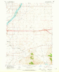 1964 Rupert SE1965 Print · USGSAgricultural life in Cassia County during the mid-sixties revolved around the town of Declo and its sophisticated irrigation network. Genealogists and researchers can trace the Old Railroad Grade, locate the High Sch, and find family-named sites like the Newcomb Substation.2 unique versions available
 - 1964 Map of Rupert SW, 1966 Print
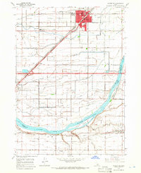 1964 Rupert SW1966 Print · USGSMinidoka County agriculture and rail life are at the forefront in the mid-1960s, showing the intersection of the Snake River and the Union Pacific line. Trace the development of Rupert and find rural landmarks like the Declo Cem, Springdale Sch, and the County Fairgrounds.3 unique versions available
 - 1993 Map of Lake Walcott, 1994 Print
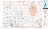 1993 Lake Walcott1994 Print · USGSMinidoka and Cassia counties come to life in the early nineties, showing a landscape shaped by the Snake River and extensive irrigation. Genealogists and local historians can trace family roots in Rupert, Burley, and smaller railroad stops like Kimama or Adelaide.
End of results
Showing maps 1-5 of 5
Top cities near Declo
- Burley historical maps
- Rupert historical maps
- Heyburn historical maps
- Paul historical maps
- Albion historical maps
- Acequia historical maps
Frequently asked questions
- What are the different types of historical maps available for Declo?
- What is the oldest map of Declo?
- Where can I purchase historical maps of Declo for my home or office?
- Where can I download high-res historical maps of Declo?
- Are there historical topographic maps available for Declo?
- Is there historical aerial imagery available for Declo?
- Where are historical maps of Declo sourced from?