1990s Maps of Mackay, Idaho
Explore 2 historic maps of Mackay from the 1990s. These maps offer a rare glimpse into what life looked like during the 1990s — showing old roads, neighborhoods, homes, and landmarks that have changed or disappeared over time.
Whether you're researching your family's past, planning a metal detecting trip, or studying how Mackay's landscape evolved across the 1990s, these high-resolution maps are a powerful tool for exploring the history of this region.
- Focus on a specific era: All maps on this page are from the 1990s, giving you a focused view of this time period.
- See what’s changed: Compare century-old streets, trails, and buildings to today's modern landscape using overlays and satellite layers.
- Research with precision: Use these maps for genealogy, historical research, land use analysis, or educational projects.
- View, download, or print: Maps are fully viewable online in high resolution, and can be downloaded or printed for your own records.
Start exploring Mackay's history through authentic maps from the 1990s. This is your window into the past.
Mackay, ID maps
(2)- 1991 Map of Mackay
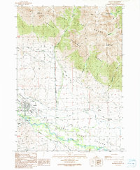 1991 Mackay1991 Print · USGSThe valley of the Big Lost River near Mackay appears here during the early nineties, showing a landscape defined by irrigation and early mining. Genealogists and historians can trace the Old Railroad Grade, locate the Empire Smelter, and identify family sites near Houston and the Mount McCaleb Cem.
 - 1991 Map of Mackay Reservoir
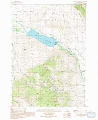 1991 Mackay Reservoir1991 Print · USGSCuster County's industrial and water-management history is on full display in the early nineties, focused on the heights above the Big Lost River. Local researchers can trace mining operations at the Empire Mine or locate the Battleground Cem near the shores of Mackay Reservoir.
End of results
Showing maps 1-2 of 2
Frequently asked questions
- What are the different types of historical maps available for Mackay?
- What is the oldest map of Mackay?
- Where can I purchase historical maps of Mackay for my home or office?
- Where can I download high-res historical maps of Mackay?
- Are there historical topographic maps available for Mackay?
- Is there historical aerial imagery available for Mackay?
- Where are historical maps of Mackay sourced from?