1900s (20th Century) Maps of Grangeville, Idaho
Explore 7 historic maps of Grangeville from the 1900s (20th Century). These maps offer a rare glimpse into what life looked like during the 1900s — showing old roads, neighborhoods, homes, and landmarks that have changed or disappeared over time.
Whether you're researching your family's past, planning a metal detecting trip, or studying how Grangeville's landscape evolved across the 1900s, these high-resolution maps are a powerful tool for exploring the history of this region.
- Focus on a specific era: All maps on this page are from the 1900s, giving you a focused view of this time period.
- See what’s changed: Compare century-old streets, trails, and buildings to today's modern landscape using overlays and satellite layers.
- Research with precision: Use these maps for genealogy, historical research, land use analysis, or educational projects.
- View, download, or print: Maps are fully viewable online in high resolution, and can be downloaded or printed for your own records.
Start exploring Grangeville's history through authentic maps from the 1900s. This is your window into the past.
Grangeville, ID maps
(7)- 1955 Map of Grangeville, 1964 Print
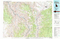
 1955 Grangeville1964 Print · USGSThe high country of the Idaho-Oregon border comes alive in the mid-1950s, showing the deep river canyons and mountain peaks. Trace the Union Pacific RR through the valleys or locate settlements like Grangeville, Joseph, and the shoreline of Wallowa Lake.4 unique versions available
 - 1959 Map of Grangeville
 1959 Grangeville1959 Print · USGSThe high alpine peaks and deep river canyons of the Idaho-Oregon borderlands are captured in the late fifties. Researchers can trace the Union Pacific RR through the valleys to settlements like Enterprise, Union, and Grangeville.2 unique versions available
 - 1963 Map of Grangeville West, 1964 Print
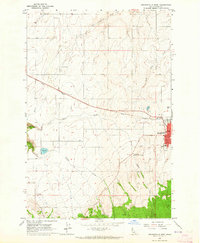 1963 Grangeville West1964 Print · USGSGrangeville and its Idaho County environs are captured here in the early sixties, showing the town at the edge of the Camas Prairie. Researchers can trace local landmarks like Tolo Lake, the County Airport, and the small settlement of Denver.2 unique versions available
 - 1963 Map of Grangeville East, 1965 Print
 1963 Grangeville East1965 Print · USGSGrangeville and the surrounding Camas Prairie are captured in the early sixties as the regional hub transitioned into a modern era. Researchers can locate family landmarks like Fairview Cem, the site of the Dewey Mine, and the mid-century Drive-in Theater.
 - 1980 Map of Grangeville
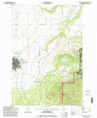
 1980 Grangeville1980 Print · USGSGrangeville and the surrounding Camas Prairie are captured in the late twentieth century as the region balanced agriculture with its deep mining roots. Discover the locations of the Dewey Mine, the remote settlement of Florence, and the winding path of the Salmon River.
 - 1995 Map of Grangeville East, 1999 Print
 1995 Grangeville East1999 Print · USGSGrangeville and the surrounding Camas Prairie landscape are captured here in the mid-1990s as the town expanded toward the national forest. Researchers can locate the Fairview Cemetery, trace the Dewey Mine, or find the historic County Farm and Mount Idaho.
 - 1995 Map of Grangeville West, 1999 Print
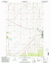 1995 Grangeville West1999 Print · USGSThe Camas Prairie of the mid-1990s unfolds around Grangeville, showing the intersection of rural agriculture and growing civic infrastructure. Researchers can trace family landmarks along Trueblood Lane, locate the historic waters of Tolo Lake, or study the layout of the County Airport.
End of results
Showing maps 1-7 of 7
Top cities near Grangeville
Frequently asked questions
- What are the different types of historical maps available for Grangeville?
- What is the oldest map of Grangeville?
- Where can I purchase historical maps of Grangeville for my home or office?
- Where can I download high-res historical maps of Grangeville?
- Are there historical topographic maps available for Grangeville?
- Is there historical aerial imagery available for Grangeville?
- Where are historical maps of Grangeville sourced from?