1900s (20th Century) Maps of Ririe, Idaho
Explore 8 historic maps of Ririe from the 1900s (20th Century). These maps offer a rare glimpse into what life looked like during the 1900s — showing old roads, neighborhoods, homes, and landmarks that have changed or disappeared over time.
Whether you're researching your family's past, planning a metal detecting trip, or studying how Ririe's landscape evolved across the 1900s, these high-resolution maps are a powerful tool for exploring the history of this region.
- Focus on a specific era: All maps on this page are from the 1900s, giving you a focused view of this time period.
- See what’s changed: Compare century-old streets, trails, and buildings to today's modern landscape using overlays and satellite layers.
- Research with precision: Use these maps for genealogy, historical research, land use analysis, or educational projects.
- View, download, or print: Maps are fully viewable online in high resolution, and can be downloaded or printed for your own records.
Start exploring Ririe's history through authentic maps from the 1900s. This is your window into the past.
Ririe, ID maps
(8)- 1950 Map of Ririe
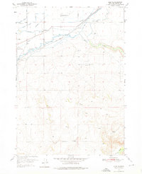
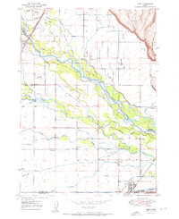 1950 Ririe1950 Print · USGSSoutheast Idaho at mid-century reveals a landscape transformed by the Snake River and its vast irrigation network. Researchers can trace family ties through Ririe and Sunnydell, or locate rural landmarks like Clark Sch and Sutton Cem.3 unique versions available
 - 1950 Map of Rigby, 1953 Print
 1950 Rigby1953 Print · USGSThe Snake River valley in the early postwar years was a thriving network of irrigated farms and railroad towns. Genealogists and local historians can trace the foundations of Rigby and Ririe, locating vanished landmarks like Bucks Sch (Aband) or Milo Cem.
 - 1950 Map of Rigby SE, 1976 Print
 1950 Rigby SE1976 Print · USGSBonneville County irrigation and upland farming are documented here just after the war, showing the complex canal systems of the Upper Snake River Valley. Genealogists can locate family sites near the Shelton Ward Church, Milo Cemetery, and the Bucks Sch (Aband).2 unique versions available
 - 1951 Map of Rigby SE
 1951 Rigby SE1951 Print · USGSSoutheast of Rigby in the early 1950s, this Idaho landscape shows a community built around complex irrigation and the Union Pacific rail line. Researchers can trace family sites at Milo Cemetery or locate the Shelton Ward Church and the formerly active Bucks Sch (Aband).
 - 1955 Map of Driggs, 1967 Print
 1955 Driggs1967 Print · USGSEastern Idaho and Western Wyoming appear at a mid-century crossroads as the river valleys were fully settled and the high peaks protected. Genealogists and researchers can trace the rail towns of Rexburg and Driggs or follow the Snake River from Irwin to the Palisades Reservoir.3 unique versions available
 - 1958 Map of Driggs
 1958 Driggs1958 Print · USGSThe high Teton peaks and Snake River valleys are captured here in the mid-fifties, showing the region's agricultural and wilderness boundaries. Researchers can trace the Union Pacific rail corridor through Rexburg or locate early settlements like Clementsville and Tetonia.2 unique versions available
 - 1962 Map of Driggs
 1962 Driggs1962 Print · USGSThe Idaho-Wyoming borderlands are captured here in the early sixties, showing the peaks and valleys of the northern Rockies. Genealogists and historians can trace rail lines like the Union Pacific RR and isolated outposts like the National Elk Refuge or the Fort Hall Indian Reservation.
 - 1988 Map of Rexburg, 1989 Print
 1988 Rexburg1989 Print · USGSThe Upper Snake River Valley in the late eighties shows a region shaped by water and agriculture. Genealogists and historians can locate family plots at the Rexburg Cemetery or trace the early paths of the Union Pacific Railroad through towns like Sugar City and Newdale.
End of results
Showing maps 1-8 of 8
Top cities near Ririe
- Idaho Falls historical maps
- Rexburg historical maps
- Ammon historical maps
- Rigby historical maps
- Iona historical maps
- Ucon historical maps
See more
Frequently asked questions
- What are the different types of historical maps available for Ririe?
- What is the oldest map of Ririe?
- Where can I purchase historical maps of Ririe for my home or office?
- Where can I download high-res historical maps of Ririe?
- Are there historical topographic maps available for Ririe?
- Is there historical aerial imagery available for Ririe?
- Where are historical maps of Ririe sourced from?