1970s Maps of Hauser, Idaho
Explore 5 historic maps of Hauser from the 1970s. These maps offer a rare glimpse into what life looked like during the 1970s — showing old roads, neighborhoods, homes, and landmarks that have changed or disappeared over time.
Whether you're researching your family's past, planning a metal detecting trip, or studying how Hauser's landscape evolved across the 1970s, these high-resolution maps are a powerful tool for exploring the history of this region.
- Focus on a specific era: All maps on this page are from the 1970s, giving you a focused view of this time period.
- See what’s changed: Compare century-old streets, trails, and buildings to today's modern landscape using overlays and satellite layers.
- Research with precision: Use these maps for genealogy, historical research, land use analysis, or educational projects.
- View, download, or print: Maps are fully viewable online in high resolution, and can be downloaded or printed for your own records.
Start exploring Hauser's history through authentic maps from the 1970s. This is your window into the past.
Hauser, ID maps
(5)- 1973 Map of Newman Lake, 1977 Print
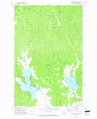 1973 Newman Lake1977 Print · USGSThe Washington-Idaho borderlands in the early 1970s reveal a landscape of deep timber and popular lakeside retreats. Genealogists and local historians can trace the development of Hauser and the many private coves of Newman Lake, from Sutton Bay to Cherokee Bay.3 unique versions available
 - 1973 Map of Liberty Lake, 1977 Print
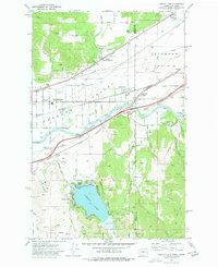 1973 Liberty Lake1977 Print · USGSSpokane Valley and the Idaho borderlands are captured here in the early seventies during a period of suburban and industrial growth. Researchers can trace the rail-and-river economy through landmarks like Moab, the Hauser siding, and the Saltese Flats.2 unique versions available
 - 1975 Map of Greenacres NE, 1981 Print
 1975 Greenacres NE1981 Print · USGSThe Washington-Idaho borderlands come into sharp focus in the mid-seventies, showing the agricultural and residential patterns of the Spokane Valley. Trace the development of State Line Village and the rural surroundings of Newman Lake and Liberty Lake.
 - 1978 Map of Newman Lake, 1981 Print
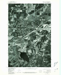
 1978 Newman Lake1981 Print · USGSNewman Lake and the surrounding peaks are captured in detailed aerial imagery during the late seventies. Researchers can trace the exact 1978 shoreline of Newman Lake and the timber patterns across Ragged Mountain and Green Mountain.
 - 1978 Map of Liberty Lake, 1981 Print
 1978 Liberty Lake1981 Print · USGSLiberty Lake and the Spokane River corridor are captured in detail during the late seventies as residential growth began to reshape the valley. Researchers can trace land development around Liberty Lake or locate the settlement of Moab near the water.
End of results
Showing maps 1-5 of 5
Top cities near Hauser
- Spokane Valley historical maps
- Coeur d'Alene historical maps
- Post Falls historical maps
- Hayden historical maps
- Liberty Lake historical maps
- Rathdrum historical maps
See more
Frequently asked questions
- What are the different types of historical maps available for Hauser?
- What is the oldest map of Hauser?
- Where can I purchase historical maps of Hauser for my home or office?
- Where can I download high-res historical maps of Hauser?
- Are there historical topographic maps available for Hauser?
- Is there historical aerial imagery available for Hauser?
- Where are historical maps of Hauser sourced from?