1900s (20th Century) Maps of Salmon, Idaho
Explore 11 historic maps of Salmon from the 1900s (20th Century). These maps offer a rare glimpse into what life looked like during the 1900s — showing old roads, neighborhoods, homes, and landmarks that have changed or disappeared over time.
Whether you're researching your family's past, planning a metal detecting trip, or studying how Salmon's landscape evolved across the 1900s, these high-resolution maps are a powerful tool for exploring the history of this region.
- Focus on a specific era: All maps on this page are from the 1900s, giving you a focused view of this time period.
- See what’s changed: Compare century-old streets, trails, and buildings to today's modern landscape using overlays and satellite layers.
- Research with precision: Use these maps for genealogy, historical research, land use analysis, or educational projects.
- View, download, or print: Maps are fully viewable online in high resolution, and can be downloaded or printed for your own records.
Start exploring Salmon's history through authentic maps from the 1900s. This is your window into the past.
Salmon, ID maps
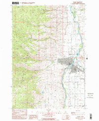
(11)- 1950 Map of Salmon, 1962 Print
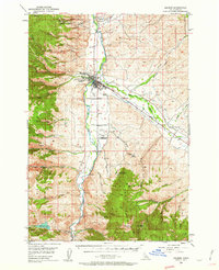 1950 Salmon1962 Print · USGSSalmon and the surrounding river valleys are captured here in the early 1950s, showing a landscape defined by mining, ranching, and mountain aviation. Researchers can trace historic claims like the Queen of the Hills Mine or find local landmarks such as the Geertson Creek Sch and Williams Lake.3 unique versions available
 - 1951 Map of Salmon
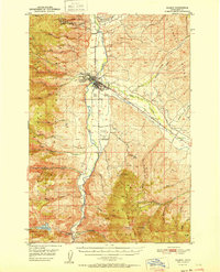 1951 Salmon1951 Print · USGSSalmon, Idaho, sits at the heart of the Lemhi Valley in the early fifties, where the river-fed agricultural lands meet the mining-rich Bitterroot and Salmon River Mountains. Genealogists and historians can trace old homesteads like Lake Creek Ranch, find the Geertson Creek Sch, or locate historic workings such as the Queen of the Hills Mine.
 - 1955 Map of Dillon, 1978 Print
 1955 Dillon1978 Print · USGSSouthwest Montana at the dawn of the interstate era reveals a landscape of high-mountain ranching and historic mining camps. Trace the routes of the Union Pacific through Dillon and Armstead, or locate early settlements like Bannack and Wisdom.2 unique versions available
 - 1957 Map of Dillon
 1957 Dillon1957 Print · USGSSouthwest Montana and Idaho in the mid-fifties reveal a high-country landscape of mountain ranges and ranching valleys. Genealogists can trace family holdings and rail stops along the Union Pacific Railroad, from Dillon to historic Virginia City and Twin Bridges.
 - 1958 Map of Dillon
 1958 Dillon1958 Print · USGSSouthwestern Montana during the late fifties reveals a high-country landscape defined by the Continental Divide and a legacy of mountain mining. Genealogists and historians can trace rail lines like the Union Pacific or locate early industrial sites including the Hecla Mine and Ermont Mine.
 - 1962 Map of Dillon
 1962 Dillon1962 Print · USGSSouthwest Montana in the early sixties is defined by its high mountain ranges and the winding rivers that carved its settlement patterns. Trace the rail routes of the Union Pacific through Dillon or locate mining activity near Butte and Argenta.
 - 1965 Map of Dillon
 1965 Dillon1965 Print · USGSSouthwest Montana in the mid-1960s is defined by its rugged river valleys and high mountain passes along the Continental Divide. Researchers can trace the path of the Union Pacific through Dillon and Armstead, or locate early mining activity near Melrose and Wise River.
 - 1974 Map of Salmon NW, 1977 Print
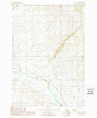
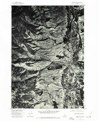 1974 Salmon NW1977 Print · USGSThe Lemhi County seat and its riverfront come into focus in the mid-1970s through this aerial-photograph survey. Researchers can trace the town layout of Salmon and the rugged topography of Pollard Canyon along the Salmon River.
 - 1981 Map of Salmon, 1982 Print
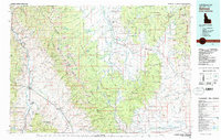 1981 Salmon1982 Print · USGSThe high mountain border between Idaho and Montana comes alive in the early 1980s as a landscape of remote mines and river junctions. Researchers can trace the heritage of the Beaverhead Mountains through sites like Elkhorn Mine, Silver King Mine, and the settlement of Wisdom.
 - 1989 Map of Salmon
 1989 Salmon1989 Print · USGSThe Salmon and Lemhi rivers converge here in the late 1980s, marking a rugged era of Idaho mining and mountain commerce. Researchers can trace the town’s layout from the High School to the Queen of the Hills Mine and the Cemetery.
 - 1989 Map of East of Salmon
 1989 East of Salmon1989 Print · USGSThe Lemhi River valley in the late 1980s reveals a rugged landscape defined by its vital waterways and upland mining operations. Researchers can trace irrigation networks along Lemhi River or locate industrial sites like the Open Pit Mine and the Graveyard.
End of results
Showing maps 1-11 of 11
Top neighborhoods of Salmon
Frequently asked questions
- What are the different types of historical maps available for Salmon?
- What is the oldest map of Salmon?
- Where can I purchase historical maps of Salmon for my home or office?
- Where can I download high-res historical maps of Salmon?
- Are there historical topographic maps available for Salmon?
- Is there historical aerial imagery available for Salmon?
- Where are historical maps of Salmon sourced from?