1900s (20th Century) Maps of Homedale, Idaho
Explore 6 historic maps of Homedale from the 1900s (20th Century). These maps offer a rare glimpse into what life looked like during the 1900s — showing old roads, neighborhoods, homes, and landmarks that have changed or disappeared over time.
Whether you're researching your family's past, planning a metal detecting trip, or studying how Homedale's landscape evolved across the 1900s, these high-resolution maps are a powerful tool for exploring the history of this region.
- Focus on a specific era: All maps on this page are from the 1900s, giving you a focused view of this time period.
- See what’s changed: Compare century-old streets, trails, and buildings to today's modern landscape using overlays and satellite layers.
- Research with precision: Use these maps for genealogy, historical research, land use analysis, or educational projects.
- View, download, or print: Maps are fully viewable online in high resolution, and can be downloaded or printed for your own records.
Start exploring Homedale's history through authentic maps from the 1900s. This is your window into the past.
Homedale, ID maps
(6)- 1955 Map of Boise, 1977 Print
 1955 Boise1977 Print · USGSThe Treasure Valley and Owyhee uplands are shown in detail during the mid-fifties, capturing the region's transition into a major agricultural and urban hub. Researchers can trace the Union Pacific line through Nampa, explore the volcanic Jordan Craters, or locate the historic mining district of Silver City.
 - 1957 Map of Wilder, 1959 Print
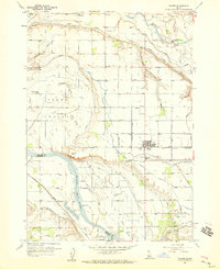 1957 Wilder1959 Print · USGSIn the late 1950s, the western Idaho borderlands near Homedale were defined by a complex irrigation network of canals and laterals. Researchers can trace the Union Pacific line through Wilder or locate the Arena Valley School and Fargo Cemetery.3 unique versions available
 - 1958 Map of Boise
 1958 Boise1958 Print · USGSThe Treasure Valley and Snake River Plain come alive in the mid-fifties as the rail-and-river economy transitions into a modern agricultural hub. Trace the Union Pacific lines through Nampa or locate remote landmarks like Initial Point and the Rockville settlement.2 unique versions available
 - 1958 Map of Homedale, 1960 Print
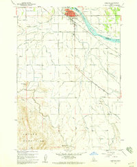 1958 Homedale1960 Print · USGSHomedale and the Snake River valley come to life in the late fifties, showing a landscape defined by intensive irrigation and river transport. Genealogists and local historians can trace the Union Pacific rail corridor, the Labor Camp, and the Poison Creek Stage Sta.2 unique versions available
 - 1962 Map of Boise
 1962 Boise1962 Print · USGSThe Treasure Valley at the start of the sixties reveals a landscape of expanding towns and complex irrigation networks along the Snake River. Genealogists and historians can trace the foundations of modern Idaho through markers like Initial Point, the mining history of Silver City, and the early infrastructure of Lucky Peak Dam.
 - 1981 Map of Boise
 1981 Boise1981 Print · USGSThe Boise River valley and Treasure Plain are captured here in the early eighties as urban expansion began to link the regional hubs of the Snake River plain. Researchers can trace the development of Nampa, Caldwell, and Meridian or locate landmarks like Lake Lowell and Eagle Island State Park.2 unique versions available
End of results
Showing maps 1-6 of 6
Top cities near Homedale
- Caldwell historical maps
- Parma historical maps
- Wilder historical maps
- Marsing historical maps
- Greenleaf historical maps
- Notus historical maps
See more
Frequently asked questions
- What are the different types of historical maps available for Homedale?
- What is the oldest map of Homedale?
- Where can I purchase historical maps of Homedale for my home or office?
- Where can I download high-res historical maps of Homedale?
- Are there historical topographic maps available for Homedale?
- Is there historical aerial imagery available for Homedale?
- Where are historical maps of Homedale sourced from?