Old Maps of Emerald Creek, Idaho
Explore 11 old maps of Emerald Creek, spanning from 1955 to today. These high-resolution historic maps reveal how streets, neighborhoods, landmarks, and natural features evolved over time — perfect for genealogy, metal detecting, research, and local history exploration.
What you can do with these maps:
- See how Emerald Creek changed over time: Compare historical maps to modern-day views to trace roads, homesites, rail lines & more.
- View detailed metadata: Each map includes creators, publishers, year, scale, and archive source.
- Overlay maps with satellite & LiDAR: Visualize the past alongside modern tools to explore terrain & human change.
- Trusted historical sources: Maps sourced from the USGS, Library of Congress, and other archives.
- Access maps your way: View online, download high-res files, or order prints for personal or research use.
Start exploring old maps of Emerald Creek to uncover forgotten places, hidden landmarks, and the deep history beneath your feet.
Emerald Creek, ID maps
(11)- 1955 Map of Spokane, 1965 Print
 1955 Spokane1965 Print · USGSInland Empire life in the fifties and sixties centers on the growth of Spokane and the heavy mining industry of northern Idaho. Trace mid-century landmarks like Fairchild Air Force Base, the Bunker Hill Mine, and early campuses such as Gonzaga University.2 unique versions available
 - 1958 Map of Spokane
 1958 Spokane1958 Print · USGSThe Inland Empire is shown at a mid-century peak of industrial and military activity, from the rail hubs of Spokane to the deep silver mines of northern Idaho. Researchers can trace the sprawling rail lines of the Union Pacific RR or locate landmarks like Fairchild Air Force Base and the Bunker Hill Smelter & Mine.
 - 1961 Map of Fernwood, 1963 Print
 1961 Fernwood1963 Print · USGSThe St Maries River valley and the surrounding timberlands are captured here in the early 1960s. Researchers can trace the route of the Chicago Milwaukee St Paul and Pacific railroad through Fernwood and find local landmarks like the Cem at Santa.2 unique versions available
 - 1981 Map of St Maries
 1981 St Maries1981 Print · USGSThe timber and rail hub of St. Maries is captured here in the early 1980s as the river-and-rail economy defined the Panhandle. Researchers can trace historic transport corridors including the Union Pacific tracks and remote landings along the St Joe River and Chatcolet Lake.2 unique versions available
 - 1990 Map of Clarkia, 1991 Print
 1990 Clarkia1991 Print · USGSThe Idaho Panhandle's timber and mining country comes to life in the 1990s as the St Maries River carves through these mountains. Genealogists and researchers can trace the settlement of Clarkia, find Jims Spur, or locate the extensive Dredge Tailings along the valley floor.
 - 1995 Map of Clarkia, 1997 Print
 1995 Clarkia1997 Print · USGSThe timber and mining country of Shoshone County comes alive in the mid-nineties, centered on the settlement of Clarkia. Researchers can trace the legacy of resource extraction through dredge tailings and Jims Spur along the St Maries River.2 unique versions available
 - 2011 Map of Clarkia, 2011 Print
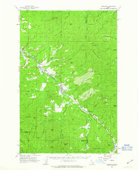
 2011 Clarkia2011 Print · USGSCovers Emerald Creek, including Clarkia, Latah County, and other nearby areas
 - 2013 Map of Clarkia, 2013 Print
 2013 Clarkia2013 Print · USGSCovers Emerald Creek, including Clarkia, Latah County, and other nearby areas
 - 2017 Map of Clarkia, 2017 Print
 2017 Clarkia2017 Print · USGSCovers Emerald Creek, including Clarkia, Latah County, and other nearby areas
 - 2020 Map of Clarkia, 2020 Print
 2020 Clarkia2020 Print · USGSCovers Emerald Creek, including Clarkia, Latah County, and other nearby areas
 - 2024 Map of Clarkia, 2024 Print
 2024 Clarkia2024 Print · USGSThe mountain valleys of northern Idaho are captured here in the early twenty-first century as the Saint Maries River flows through the timberlands of Shoshone and Benewah counties. Local historians can trace the roads and trails connecting Clarkia, Fernwood, and specialized routes like the Garnet Stone OHV Trl.
End of results
Showing maps 1-11 of 11
Top cities near Emerald Creek
Frequently asked questions
- What are the different types of historical maps available for Emerald Creek?
- What is the oldest map of Emerald Creek?
- Where can I purchase historical maps of Emerald Creek for my home or office?
- Where can I download high-res historical maps of Emerald Creek?
- Are there historical topographic maps available for Emerald Creek?
- Is there historical aerial imagery available for Emerald Creek?
- Where are historical maps of Emerald Creek sourced from?