1980s Maps of Osburn, Idaho
Explore 4 historic maps of Osburn from the 1980s. These maps offer a rare glimpse into what life looked like during the 1980s — showing old roads, neighborhoods, homes, and landmarks that have changed or disappeared over time.
Whether you're researching your family's past, planning a metal detecting trip, or studying how Osburn's landscape evolved across the 1980s, these high-resolution maps are a powerful tool for exploring the history of this region.
- Focus on a specific era: All maps on this page are from the 1980s, giving you a focused view of this time period.
- See what’s changed: Compare century-old streets, trails, and buildings to today's modern landscape using overlays and satellite layers.
- Research with precision: Use these maps for genealogy, historical research, land use analysis, or educational projects.
- View, download, or print: Maps are fully viewable online in high resolution, and can be downloaded or printed for your own records.
Start exploring Osburn's history through authentic maps from the 1980s. This is your window into the past.
Osburn, ID maps
(4)- 1985 Map of Kellogg East
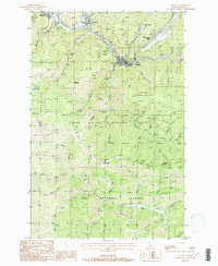
 1985 Kellogg East1985 Print · USGSThe Silver Valley corridor in the 1980s reveals a landscape defined by the South Fork Coeur d'Alene River. Researchers can trace industrial sites like the Tailings near Shont and explore the historic layout of Kellogg, Wardner, and Osburn.2 unique versions available
 - 1985 Map of Osburn
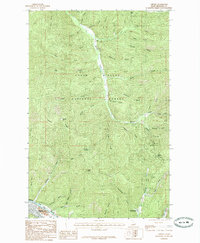 1985 Osburn1985 Print · USGSShoshone County’s mining and mountain corridors are captured here in the mid-1980s as they weave through the Idaho interior. Researchers can trace the path of Beaver Creek from the settlement of Delta down to Osburn, or locate high crossings at Kings Pass and Dobson Pass.
 - 1987 Map of Coeur D'Alene
 1987 Coeur D'Alene1987 Print · USGSNorthern Idaho in the late eighties shows a landscape of deep-water lakes and heavy industry where the timber and mining economies meet growing valley settlements. Genealogists and historians can trace the footprints of the Sunshine Mine, the rail sidings at Corbin Junction, and the historic Old Mission State Park.3 unique versions available
 - 1988 Map of Wallace
 1988 Wallace1988 Print · USGSShoshone County mining life is captured here in the late twentieth century, centered on the river-valley communities of Wallace and Silverton. Researchers can trace the legacy of the Silver Valley through local sites like the Galena Mine, Cem, and the Old RR Grade.
End of results
Showing maps 1-4 of 4
Top cities near Osburn
- Kellogg historical maps
- Pinehurst historical maps
- Wallace historical maps
- Mullan historical maps
- Smelterville historical maps
- Wardner historical maps
Frequently asked questions
- What are the different types of historical maps available for Osburn?
- What is the oldest map of Osburn?
- Where can I purchase historical maps of Osburn for my home or office?
- Where can I download high-res historical maps of Osburn?
- Are there historical topographic maps available for Osburn?
- Is there historical aerial imagery available for Osburn?
- Where are historical maps of Osburn sourced from?