1960s Maps of Kimberly, Idaho
Explore 2 historic maps of Kimberly from the 1960s. These maps offer a rare glimpse into what life looked like during the 1960s — showing old roads, neighborhoods, homes, and landmarks that have changed or disappeared over time.
Whether you're researching your family's past, planning a metal detecting trip, or studying how Kimberly's landscape evolved across the 1960s, these high-resolution maps are a powerful tool for exploring the history of this region.
- Focus on a specific era: All maps on this page are from the 1960s, giving you a focused view of this time period.
- See what’s changed: Compare century-old streets, trails, and buildings to today's modern landscape using overlays and satellite layers.
- Research with precision: Use these maps for genealogy, historical research, land use analysis, or educational projects.
- View, download, or print: Maps are fully viewable online in high resolution, and can be downloaded or printed for your own records.
Start exploring Kimberly's history through authentic maps from the 1960s. This is your window into the past.
Kimberly, ID maps
(2)- 1964 Map of Kimberly, 1965 Print
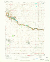 1964 Kimberly1965 Print · USGSSouthern Idaho's agricultural heartland and the deep Snake River canyon are captured here in the mid-sixties. Genealogists and local historians can trace the rail-side growth of Kimberly and Hansen or locate the historic Springtown (Site) near the Hansen Bridge.2 unique versions available
 - 1964 Map of Twin Falls, 1965 Print
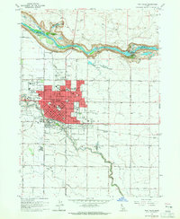 1964 Twin Falls1965 Print · USGSTwin Falls is shown at a point of significant post-war growth in the mid-sixties, with its urban center expanding toward the Snake River canyon. Researchers can trace local industry and education through the Sugar Factory, St Edwards Sch, and the Perrine Memorial Bridge.2 unique versions available
End of results
Showing maps 1-2 of 2
Top cities near Kimberly
- Twin Falls historical maps
- Jerome historical maps
- Filer historical maps
- Hansen historical maps
- Hazelton historical maps
- Eden historical maps
See more
Frequently asked questions
- What are the different types of historical maps available for Kimberly?
- What is the oldest map of Kimberly?
- Where can I purchase historical maps of Kimberly for my home or office?
- Where can I download high-res historical maps of Kimberly?
- Are there historical topographic maps available for Kimberly?
- Is there historical aerial imagery available for Kimberly?
- Where are historical maps of Kimberly sourced from?