
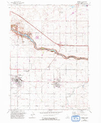
1964 Map of Kimberly
USGS Topo · Published 1965About this map
The Snake River carves a deep, dramatic course through this portion of the Magic Valley, defining the boundary between Jerome and Twin Falls counties. During the mid-1960s, the agricultural character of the region is evident in the layout of Kimberly and Hansen, both situated along the Union Pacific railroad line. The map identifies the historic location of Springtown (Site) on the riverbank, a former mining settlement that stood in contrast to the modern infrastructure of the Hansen Bridge and nearby power generation facilities like the Powerhouse and Gaging Station.
Find a feature on this map
26 named features on this map. Tap any name to fly to it.
Don’t see what you’re looking for? This feature index may not catch every label — zoom into the map to look around manually.
Map Details
Editions of this 1964 Kimberly Map
2 editions found
Other maps of this area

1955 · Twin Falls
USGS Topo · 1:250,000

1958 · Twin Falls
USGS Topo · 1:250,000

1964 · Falls City
USGS Topo · 1:24,000

1964 · Twin Falls
USGS Topo · 1:24,000

1964 · Eden
USGS Topo · 1:24,000

1964 · Perrine
USGS Topo · 1:24,000

1964 · Hunt
USGS Topo · 1:24,000

1965 · Stricker Butte
USGS Topo · 1:24,000

1965 · Hub Butte
USGS Topo · 1:24,000

1965 · Murtaugh
USGS Topo · 1:24,000