
1964 Map of Hunt
USGS Topo · Published 1965About this map
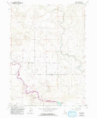
Hunt serves as the primary named settlement in this mid-1960s landscape, an area defined by the intricate engineering of the Snake River Plain's irrigation systems. The map captures a sophisticated network of water management, most notably the Milner Gooding Canal and the North Main Canal, which dictate the local topography and agricultural potential. Water infrastructure is detailed down to specific functional components, including a Siphon and a Spillway Elev 4012 associated with the Wilson Lake Reservoir. Beyond the canals, the terrain is marked by several Gravel Pits and a Gravel Pit, suggesting local industrial activity or road construction material sourcing during this era. To the north, a Jeep Trail traverses the more open ground, while Goose Lake provides a natural contrast to the man-made reservoir and canal system.
Find a feature on this map
20 named features on this map. Tap any name to fly to it.
Don’t see what you’re looking for? This feature index may not catch every label — zoom into the map to look around manually.
Map Details
Editions of this 1964 Hunt Map
2 editions found
Other maps of this area

1955 · Twin Falls
USGS Topo · 1:250,000

1958 · Twin Falls
USGS Topo · 1:250,000

1964 · Kimberly
USGS Topo · 1:24,000

1964 · Eden
USGS Topo · 1:24,000

1964 · Milner
USGS Topo · 1:24,000

1964 · Hazelton NE
USGS Topo · 1:24,000

1964 · Perrine
USGS Topo · 1:24,000
1965 · Milner
USGS Topo · 1:24,000

1971 · Shoshone SE
USGS Topo · 1:24,000

1971 · Star Lake
USGS Topo · 1:24,000