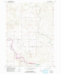
1964 Map of Hunt
USGS Topo · Published 1992About this map
The Minidoka Relocation Center stands as a significant historical site within the high desert landscape of Jerome County, marking the location of the World War II-era internment camp near Hunt. This 1964 survey, updated with late-1980s data, illustrates the complex water management infrastructure essential to the region's agricultural development. The Milner Gooding Canal and North Side Main Canal cut through the terrain, feeding into the Wilson Lake Reservoir. The map captures a transition in land use, showing localized industrial and agricultural features such as a Feedlot, several Storage Bins, and a Gravel Pit. The presence of the Footbridge over the canal and the established grid of the 4000 Road and 400 South Road reflect the human imprint on this arid environment.
Find a feature on this map
19 named features on this map. Tap any name to fly to it.
Don’t see what you’re looking for? This feature index may not catch every label — zoom into the map to look around manually.
Map Details
Editions of this 1964 Hunt Map
2 editions found
Other maps of this area

1955 · Twin Falls
USGS Topo · 1:250,000

1958 · Twin Falls
USGS Topo · 1:250,000

1964 · Kimberly
USGS Topo · 1:24,000

1964 · Eden
USGS Topo · 1:24,000

1964 · Milner
USGS Topo · 1:24,000

1964 · Hazelton NE
USGS Topo · 1:24,000

1964 · Perrine
USGS Topo · 1:24,000

1964 · Hunt
USGS Topo · 1:24,000
1965 · Milner
USGS Topo · 1:24,000

1971 · Shoshone SE
USGS Topo · 1:24,000