1980s Maps of Cascade, Idaho
Explore 4 historic maps of Cascade from the 1980s. These maps offer a rare glimpse into what life looked like during the 1980s — showing old roads, neighborhoods, homes, and landmarks that have changed or disappeared over time.
Whether you're researching your family's past, planning a metal detecting trip, or studying how Cascade's landscape evolved across the 1980s, these high-resolution maps are a powerful tool for exploring the history of this region.
- Focus on a specific era: All maps on this page are from the 1980s, giving you a focused view of this time period.
- See what’s changed: Compare century-old streets, trails, and buildings to today's modern landscape using overlays and satellite layers.
- Research with precision: Use these maps for genealogy, historical research, land use analysis, or educational projects.
- View, download, or print: Maps are fully viewable online in high resolution, and can be downloaded or printed for your own records.
Start exploring Cascade's history through authentic maps from the 1980s. This is your window into the past.
Cascade, ID maps
(4)- 1980 Map of McCall, 1993 Print
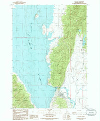
 1980 McCall1993 Print · USGSThe high timber country and glacial lakes of the West Mountains are documented here in the early eighties. Genealogists and local historians can trace the Union Pacific rail line and family-linked sites like Roseberry, Starkey, and the North Hornet Mine.2 unique versions available
 - 1980 Map of Weiser, 1993 Print
 1980 Weiser1993 Print · USGSThe Snake River valley and the foothills of the Boise Mountains are captured here in the 1980s, showing the vital rail and water infrastructure of the region. Researchers can trace the Union Pacific line through Payette or locate rural landmarks like Hog Cove Butte and Wilburn Butte.
 - 1985 Map of Alpha, 1986 Print
 1985 Alpha1986 Print · USGSLong Valley and the high West Mountains are documented here during the mid-eighties, showing the interface of timberlands and river bottom. Researchers can trace the river-and-rail corridor through Alpha, Cabarton, and Belvidere or locate remote sites like Shirts Lake.2 unique versions available
 - 1985 Map of Cascade, 1986 Print
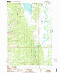
 1985 Cascade1986 Print · USGSValley County is shown in the mid-1980s as the town of Cascade sits along its namesake reservoir. Researchers can trace the Old R R Grade and locate features like the Landing Strip, Crown Point, and the Trailer Park.
End of results
Showing maps 1-4 of 4
Top cities near Cascade
Frequently asked questions
- What are the different types of historical maps available for Cascade?
- What is the oldest map of Cascade?
- Where can I purchase historical maps of Cascade for my home or office?
- Where can I download high-res historical maps of Cascade?
- Are there historical topographic maps available for Cascade?
- Is there historical aerial imagery available for Cascade?
- Where are historical maps of Cascade sourced from?