1980s Maps of Donnelly, Idaho
Explore 2 historic maps of Donnelly from the 1980s. These maps offer a rare glimpse into what life looked like during the 1980s — showing old roads, neighborhoods, homes, and landmarks that have changed or disappeared over time.
Whether you're researching your family's past, planning a metal detecting trip, or studying how Donnelly's landscape evolved across the 1980s, these high-resolution maps are a powerful tool for exploring the history of this region.
- Focus on a specific era: All maps on this page are from the 1980s, giving you a focused view of this time period.
- See what’s changed: Compare century-old streets, trails, and buildings to today's modern landscape using overlays and satellite layers.
- Research with precision: Use these maps for genealogy, historical research, land use analysis, or educational projects.
- View, download, or print: Maps are fully viewable online in high resolution, and can be downloaded or printed for your own records.
Start exploring Donnelly's history through authentic maps from the 1980s. This is your window into the past.
Donnelly, ID maps
(2)- 1980 Map of McCall, 1993 Print
 1980 McCall1993 Print · USGSThe high timber country and glacial lakes of the West Mountains are documented here in the early eighties. Genealogists and local historians can trace the Union Pacific rail line and family-linked sites like Roseberry, Starkey, and the North Hornet Mine.2 unique versions available
 - 1985 Map of Donnelly, 1986 Print
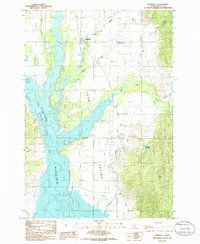 1985 Donnelly1986 Print · USGSDonnelly and the Long Valley region are documented here in the mid-eighties as the community balanced its agricultural roots with growing lakeside recreation. Genealogists and historians can trace the Old R.R. Grade, the site of Arling Hot Spr, and the original streets of Roseberry.
End of results
Showing maps 1-2 of 2
Top cities near Donnelly
Frequently asked questions
- What are the different types of historical maps available for Donnelly?
- What is the oldest map of Donnelly?
- Where can I purchase historical maps of Donnelly for my home or office?
- Where can I download high-res historical maps of Donnelly?
- Are there historical topographic maps available for Donnelly?
- Is there historical aerial imagery available for Donnelly?
- Where are historical maps of Donnelly sourced from?