1980s Maps of Adams, Illinois
Explore 2 historic maps of Adams from the 1980s. These maps offer a rare glimpse into what life looked like during the 1980s — showing old roads, neighborhoods, homes, and landmarks that have changed or disappeared over time.
Whether you're researching your family's past, planning a metal detecting trip, or studying how Adams's landscape evolved across the 1980s, these high-resolution maps are a powerful tool for exploring the history of this region.
- Focus on a specific era: All maps on this page are from the 1980s, giving you a focused view of this time period.
- See what’s changed: Compare century-old streets, trails, and buildings to today's modern landscape using overlays and satellite layers.
- Research with precision: Use these maps for genealogy, historical research, land use analysis, or educational projects.
- View, download, or print: Maps are fully viewable online in high resolution, and can be downloaded or printed for your own records.
Start exploring Adams's history through authentic maps from the 1980s. This is your window into the past.
Adams, IL maps
(2)- 1981 Map of Payson
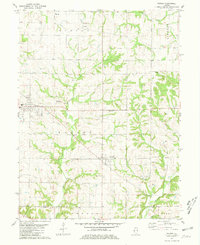 1981 Payson1981 Print · USGSSouthern Adams County in the early eighties reveals a landscape of wooded creek valleys and prairie farmsteads. Researchers can trace numerous local burial sites like Steward Cem and New Town Cem or locate rural landmarks such as the Krutmeier Landing Strip.
 - 1986 Map of Quincy
 1986 Quincy1986 Print · USGSThe tri-state border region along the Mississippi River comes into focus during the mid-1980s. Researchers can trace the legacy of river towns and rail hubs like Quincy and Monroe City or locate landmarks such as Mount Olive Cem.2 unique versions available
End of results
Showing maps 1-2 of 2
Top cities near Adams
- Quincy historical maps
- Hannibal historical maps
- Barry historical maps
- Camp Point historical maps
- Payson historical maps
- Mendon historical maps
See more
Frequently asked questions
- What are the different types of historical maps available for Adams?
- What is the oldest map of Adams?
- Where can I purchase historical maps of Adams for my home or office?
- Where can I download high-res historical maps of Adams?
- Are there historical topographic maps available for Adams?
- Is there historical aerial imagery available for Adams?
- Where are historical maps of Adams sourced from?