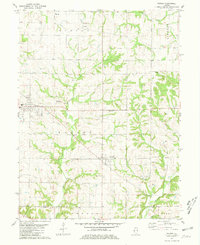
1981 Map of Payson
USGS Topo · Published 1981About this map
Payson and Plainville anchor this southern Adams County landscape, illustrating a late-twentieth-century pattern of rural Illinois life. The topography is defined by the drainage networks of Pigeon Creek and Tournear Creek, which carve deep, wooded fingers through the agricultural uplands. A striking concentration of family and community burial grounds, including Tandy Cem, Nichols Cem, and Franks Cem, offers significant detail for genealogists tracing the early settlement of Burton and Payson townships. Evidence of local infrastructure and industry appears in the Krutmeier Landing Strip and a nearby Quarry, while the southern border traces the line between Adams and Pike Counties. The map preserves the exact locations of rural institutions like the High Sch and Shiloh Cem, showing how these small hubs organized the social geography of the prairie before modern consolidation.
Find a feature on this map
27 named features on this map. Tap any name to fly to it.
Don’t see what you’re looking for? This feature index may not catch every label — zoom into the map to look around manually.
Map Details
Editions of this 1981 Payson Map
This is the sole edition of this map. No revisions or reprints were ever made.
Other maps of this area

1925 · Quincy
USGS Topo · 1:62,500

1925 · Liberty
USGS Topo · 1:62,500

1927 · Liberty
USGS Topo · 1:62,500

1931 · Barry
USGS Topo · 1:62,500

1932 · Hannibal
USGS Topo · 1:62,500

1936 · Hannibal
USGS Topo · 1:48,000

1936 · Barry
USGS Topo · 1:48,000

1944 · Barry
USGS Topo · 1:62,500

1944 · Quincy
USGS Topo · 1:62,500

1945 · Hannibal
USGS Topo · 1:62,500