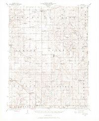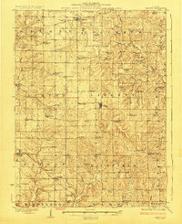
1927 Map of Liberty
USGS Topo · Published 1927About this map
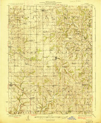
Liberty and its surrounding townships in Adams County are defined by a dense network of country schools and churches as they appeared in the mid-1920s. This survey, conducted by J. H. Jennings and J. G. Staack, reveals a rural landscape where education was highly localized, evidenced by the staggering number of named one-room schoolhouses like Maple Grove School, Oregon School, and California School. The topography is shaped by the drainage basins of McKee Creek and McCraney Creek, which carve deep contours into the Illinois prairie. Smaller hamlets such as Plainville and Kingston serve as central nodes for the agricultural community. Genealogists will find particular value in the placement of landmarks like Mt Pleasant Church and the Lost Prairie Church, providing a spatial record of local congregations before mid-century school consolidations and road improvements altered the township's social fabric.
Find a feature on this map
74 named features on this map. Tap any name to fly to it.
Don’t see what you’re looking for? This feature index may not catch every label — zoom into the map to look around manually.
Map Details
Editions of this 1927 Liberty Map
2 editions found
Historical Maps of Payson Through Time
8 maps found