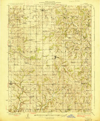
1927 Map of Liberty
USGS Topo · Published 1927About this map
Liberty serves as a central hub for this rural Illinois landscape, which is defined by a dense network of country schools and churches situated between the winding waters of Mc Kee Creek and Mill Creek. The map reveals a highly decentralized educational system, where every few miles a named schoolhouse like Franklin School, Robinson School, or Seigel School anchored the local farming community. These small institutions, along with gathering points like Lost Prairie Church, reflect the early 20th-century social fabric of eastern Adams County before the consolidation of rural districts.
Find a feature on this map
74 named features on this map. Tap any name to fly to it.
Don’t see what you’re looking for? This feature index may not catch every label — zoom into the map to look around manually.
Map Details
Editions of this 1927 Liberty Map
2 editions found
Other maps of this area

1925 · Quincy
USGS Topo · 1:62,500

1925 · Liberty
USGS Topo · 1:62,500

1926 · Pittsfield
USGS Topo · 1:62,500

1926 · Mt Sterling
USGS Topo · 1:62,500

1927 · Liberty
USGS Topo · 1:62,500

1929 · Mt Sterling
USGS Topo · 1:62,500

1931 · Barry
USGS Topo · 1:62,500

1932 · Hannibal
USGS Topo · 1:62,500

1936 · Hannibal
USGS Topo · 1:48,000

1936 · Barry
USGS Topo · 1:48,000