1980s Maps of Mount Sterling, Illinois
Explore 3 historic maps of Mount Sterling from the 1980s. These maps offer a rare glimpse into what life looked like during the 1980s — showing old roads, neighborhoods, homes, and landmarks that have changed or disappeared over time.
Whether you're researching your family's past, planning a metal detecting trip, or studying how Mount Sterling's landscape evolved across the 1980s, these high-resolution maps are a powerful tool for exploring the history of this region.
- Focus on a specific era: All maps on this page are from the 1980s, giving you a focused view of this time period.
- See what’s changed: Compare century-old streets, trails, and buildings to today's modern landscape using overlays and satellite layers.
- Research with precision: Use these maps for genealogy, historical research, land use analysis, or educational projects.
- View, download, or print: Maps are fully viewable online in high resolution, and can be downloaded or printed for your own records.
Start exploring Mount Sterling's history through authentic maps from the 1980s. This is your window into the past.
Mount Sterling, IL maps
(3)- 1980 Map of Versailles, 1981 Print
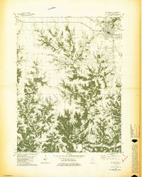
 1980 Versailles1981 Print · USGSBrown County's rural landscape is captured here in the early eighties, centered on the village of Versailles and the winding Camp Creek. Genealogists can trace family roots through numerous local burial sites, including Logan Creek, Hersman Cem, and Gilbirds Cem.
 - 1981 Map of Mt Sterling
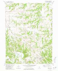
 1981 Mt Sterling1981 Print · USGSBrown County's rural townships and the county seat of Mt Sterling are captured here in the early 1980s. Genealogists and local historians can trace family roots through numerous burial sites like Cleaves Cem and Butler Cem or locate the old Fargo settlement.2 unique versions available
 - 1985 Map of Meredosia, 1988 Print
 1985 Meredosia1988 Print · USGSWest Central Illinois in the mid-eighties was a landscape of deep-rooted river towns and historic educational institutions. Genealogists and historians can trace family ties through Diamond Grove Cem, locate MacMurray College in Jacksonville, or study the river engineering at La Grange Lock and Dam.
End of results
Showing maps 1-3 of 3
Top cities near Mount Sterling
- Rushville historical maps
- Meredosia historical maps
- Clayton historical maps
- Versailles historical maps
- Perry historical maps
- Cooperstown historical maps
See more
Frequently asked questions
- What are the different types of historical maps available for Mount Sterling?
- What is the oldest map of Mount Sterling?
- Where can I purchase historical maps of Mount Sterling for my home or office?
- Where can I download high-res historical maps of Mount Sterling?
- Are there historical topographic maps available for Mount Sterling?
- Is there historical aerial imagery available for Mount Sterling?
- Where are historical maps of Mount Sterling sourced from?