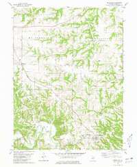
1980 Map of Versailles
USGS Topo · Published 1981About this map
Versailles serves as the primary hub in this portion of Brown County, situated south of Camp Creek where the landscape transitions from dissected uplands into the drainage basins of Elkhorn Creek and MC Kee Creek. The settlement pattern in the late 1970s reveals a high density of rural burial grounds, suggesting generations of family farmsteads throughout MT Sterling and Cooperstown townships. Notable sites like Logan Creek Cem, Huffman Cem, and Putnam Cem are scattered across the ridges, while the small community of Hersman sits to the west. An abandoned rail line cuts a diagonal path through Gilbirds, tracing the historical transportation corridor that once linked these agricultural townships before the modern emphasis on highway travel.
Find a feature on this map
35 named features on this map. Tap any name to fly to it.
Don’t see what you’re looking for? This feature index may not catch every label — zoom into the map to look around manually.
Map Details
Editions of this 1980 Versailles Map
This is the sole edition of this map. No revisions or reprints were ever made.
Other maps of this area

1923 · Rushville
USGS Topo · 1:62,500

1926 · Rushville
USGS Topo · 1:62,500

1926 · Mt Sterling
USGS Topo · 1:62,500

1928 · Meredosia
USGS Topo · 1:62,500

1929 · Mt Sterling
USGS Topo · 1:62,500

1931 · Meredosia
USGS Topo · 1:62,500

1946 · Augusta
USGS Topo · 1:62,500

1948 · Quincy
USGS Topo · 1:250,000

1949 · Augusta
USGS Topo · 1:62,500

1956 · Quincy
USGS Topo · 1:250,000