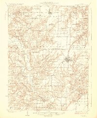
1923 Map of Rushville
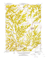
USGS Topo · Published 1958About this map
Rushville serves as the central hub of this Schuyler County landscape, where the Chicago Burlington and Quincy railroad line terminates in the heart of town. The surrounding countryside is defined by a dense network of local landmarks, reflecting the rural social fabric of the early twentieth century. Dozens of named schools such as Muley School, White Sulphur School, and Pokeberry School are spaced every few miles, alongside traditional country congregations like Bethany Church and Ebenezer Church.
Find a feature on this map
98 named features on this map. Tap any name to fly to it.
Don’t see what you’re looking for? This feature index may not catch every label — zoom into the map to look around manually.
Map Details
Editions of this 1923 Rushville Map
This is the sole edition of this map. No revisions or reprints were ever made.