
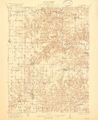
1921 Map of Vermont
USGS Topo · Published 1921About this map
The Spoon River meanders through the heart of the Bernadotte and Farmers townships, carving a rugged corridor through the central Illinois prairie. This 1921 survey illustrates a mature agricultural landscape just after the First World War, where nearly every section of land is anchored by a local schoolhouse or country church. Notable rural landmarks like the Mud Acre School, Point Pleasant Church, and North Hickory Grove School reflect a community organized around walking-distance institutions. Two major rail corridors, the Toledo Peoria and Western and the Chicago Burlington and Quincy, serve as the region's economic lifelines, connecting established settlements like Table Grove, Ipava, and Vermont to wider markets. The transition from the high prairie flats to the wooded breaks of Tarter Creek and the river valley highlights the era's reliance on the Tarter Bridge and local fords for cross-county travel.
Find a feature on this map
78 named features on this map. Tap any name to fly to it.
Don’t see what you’re looking for? This feature index may not catch every label — zoom into the map to look around manually.
Map Details
Editions of this 1921 Vermont Map
2 editions found
Other maps of this area

1912 · Canton
USGS Topo · 1:62,500

1912 · Macomb
USGS Topo · 1:62,500

1914 · Macomb
USGS Topo · 1:62,500

1915 · Avon
USGS Topo · 1:62,500

1916 · Good Hope
USGS Topo · 1:62,500

1918 · Vermont
USGS Topo · 1:62,500

1918 · Good Hope
USGS Topo · 1:62,500

1923 · Rushville
USGS Topo · 1:62,500

1925 · Havana
USGS Topo · 1:62,500

1926 · Beardstown
USGS Topo · 1:62,500