1990s Maps of Sawgrass, Champaign
Explore 3 historic maps of Sawgrass from the 1990s. These maps offer a rare glimpse into what life looked like during the 1990s — showing old roads, neighborhoods, homes, and landmarks that have changed or disappeared over time.
Whether you're researching your family's past, planning a metal detecting trip, or studying how Sawgrass's landscape evolved across the 1990s, these high-resolution maps are a powerful tool for exploring the history of this region.
- Focus on a specific era: All maps on this page are from the 1990s, giving you a focused view of this time period.
- See what’s changed: Compare century-old streets, trails, and buildings to today's modern landscape using overlays and satellite layers.
- Research with precision: Use these maps for genealogy, historical research, land use analysis, or educational projects.
- View, download, or print: Maps are fully viewable online in high resolution, and can be downloaded or printed for your own records.
Start exploring Sawgrass's history through authentic maps from the 1990s. This is your window into the past.
Sawgrass, Champaign maps
(3)- 1990 Map of Peoria
 1990 Peoria1990 Print · USGSCentral Illinois at the start of the nineties reveals a landscape of industrial river towns and sprawling university campuses. Researchers can trace the legacy of major institutions like Chanute Air Force Base and the University of Illinois alongside regional landmarks such as Sand Ridge State Forest.
 - 1998 Map of Rising, 2001 Print
 1998 Rising2001 Print · USGSChampaign and the rural townships of Hensley and Condit are shown at the close of the twentieth century. Researchers can locate numerous historic family burial sites like Phillippe Cem and Bethlehem Cem along the Illinois Central Gulf railroad line.
 - 1998 Map of Bondville, 2001 Print
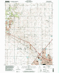
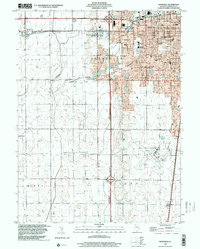 1998 Bondville2001 Print · USGSThe western suburbs of Champaign and the village of Bondville are captured in the late nineties as the urban fringe met the prairie. Trace the development of Willard Airport and find local landmarks like Prairieview Cem and Kenwood Sch.
End of results
Showing maps 1-3 of 3
Frequently asked questions
- What are the different types of historical maps available for Sawgrass?
- What is the oldest map of Sawgrass?
- Where can I purchase historical maps of Sawgrass for my home or office?
- Where can I download high-res historical maps of Sawgrass?
- Are there historical topographic maps available for Sawgrass?
- Is there historical aerial imagery available for Sawgrass?
- Where are historical maps of Sawgrass sourced from?