Old Maps of Dorans, Illinois for Hiking & Exploration
Hike through history with 12 historic maps of Dorans. Explore old trails, ghost towns, and forgotten backroads — perfect for outdoor adventurers and local explorers.
- Rediscover forgotten places: Map out old mining camps, roads, and footpaths that no longer exist on modern maps.
- Layer with modern tools: Combine with LiDAR or satellite views to plan hikes through historical terrain.
- Made for exploration: Popular among hikers, overlanders, and local history lovers.
Use these maps to find adventure and explore the hidden past of Dorans.
Dorans, IL maps
(12)- 1935 Map of Arcola
 1935 Arcola1935 Print · USGSCentral Illinois farming communities thrived along the Illinois Central and Pennsylvania rail lines in the 1930s. Genealogists can trace family roots through numerous rural landmarks like Yoder Cem, Quinn Chapel, and Pulltight Sch.3 unique versions available
 - 1940 Map of Arcola
 1940 Arcola1940 Print · USGSThe Douglas and Coles County borderlands come alive in this pre-war portrait of central Illinois agricultural life. Researchers can trace dozens of rural school sites such as Pulltight Sch and Little Red Sch, alongside old rail corridors like the Illinois Central.
 - 1958 Map of Decatur, 1971 Print
 1958 Decatur1971 Print · USGSCentral Illinois in the mid-twentieth century shows a landscape defined by industrial rail hubs and the creation of large reservoirs. Researchers can trace historic corridors like the Penn Central or locate landmarks such as Lincoln Log Cabin State Park and Lake Springfield.3 unique versions available
 - 1961 Map of Decatur
 1961 Decatur1961 Print · USGSCentral Illinois in the late fifties was a bustling corridor of rail lines and prairie commerce centered on the state capital. Genealogists and historians can trace the intricate connections between Springfield, Decatur, and dozens of smaller settlements like Nokomis and Arcola.2 unique versions available
 - 1983 Map of Humboldt
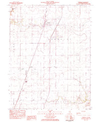 1983 Humboldt1983 Print · USGSHumboldt and its neighboring prairie settlements are captured in the early 1980s as agricultural life and rail transport intersected in Coles County. Genealogists and local historians can trace the community through St Pauls Ch, Humboldt Cem, and the small siding at Dorans.
 - 1985 Map of Decatur
 1985 Decatur1985 Print · USGSCentral Illinois farming and rail hubs thrive in the mid-1980s as Decatur anchors a sprawling network of track and timber. Trace the paths of the Sangamon River and the Illinois Central Gulf RR through old towns like Cerro Gordo and Bement.2 unique versions available
 - 1998 Map of Humboldt, 2003 Print
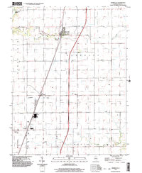 1998 Humboldt2003 Print · USGSColes County at the close of the twentieth century shows a landscape defined by prairie drainage and rail transit. Genealogists and local historians can trace family plots at Township Cem or locate the community foundations of Humboldt and Dorans.
 - 2012 Map of Humboldt, 2012 Print
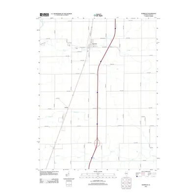 2012 Humboldt2012 Print · USGSCovers Dorans, including Mattoon, Humboldt, and other nearby areas
 - 2015 Map of Humboldt, 2015 Print
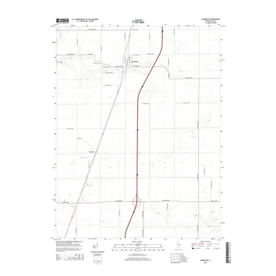 2015 Humboldt2015 Print · USGSCovers Dorans, including Mattoon, Humboldt, and other nearby areas
 - 2018 Map of Humboldt, 2018 Print
 2018 Humboldt2018 Print · USGSCovers Dorans, including Mattoon, Humboldt, and other nearby areas
 - 2021 Map of Humboldt, 2021 Print
 2021 Humboldt2021 Print · USGSCovers Dorans, including Mattoon, Humboldt, and other nearby areas
 - 2024 Map of Humboldt, 2024 Print
 2024 Humboldt2024 Print · USGSColes County at the start of the 2020s shows a landscape of steady agricultural roots and modern transit corridors. Researchers can trace family history at the Humboldt Township Cem or follow the waters of Flat Branch and Crabapple Creek.
End of results
Showing maps 1-12 of 12
Top cities near Dorans
- Charleston historical maps
- Mattoon historical maps
- Tuscola historical maps
- Arcola historical maps
- Neoga historical maps
- Paradise historical maps
See more
Frequently asked questions
- What are the different types of historical maps available for Dorans?
- What is the oldest map of Dorans?
- Where can I purchase historical maps of Dorans for my home or office?
- Where can I download high-res historical maps of Dorans?
- Are there historical topographic maps available for Dorans?
- Is there historical aerial imagery available for Dorans?
- Where are historical maps of Dorans sourced from?